Thursday, February 28, 2013

El Dorado County, California Bridges: Mt Aukum Rd Bridge across the Middle Fork of the Cosumnes River (1)

January 2013 (38.6254 Degrees, -102.7015 Degrees) Mount Aukum Road Bridge
Just east of State Route 49, the Cosumnes River splits into several forks. The Middle Fork goes east for about 20 miles before it is crossed by two bridges at Mount Aukum Road (County Road E16).  The newer Middle Fork of the Cosumnes River Bridge (25C0027) is a 3-span steel girder bridge (built in 1968) on a 40 degree skew with a 38.6 m length middle span.

A bridge with steel girders and steel columns is quite unusual for California. I've noticed that whenever a bridge engineer gets an opportunity, they like to slope their bents. Unfortunately, the earthquake performance suffers as a result of the increased axial load and shear in sloping bents.

We'll take a closer look at this interesting bridge tomorrow.
Creative Commons License
El Dorado County, California Bridges: Mt Aukum Bridge across the Middle Fork of the Cosumnes River (1) by Mark Yashinsky is licensed under a Creative Commons Attribution-NonCommercial-ShareAlike 3.0 United States License.

Wednesday, February 27, 2013

El Dorado County, California Bridges: SR 49 Bridge across the Cosumnes River

February 2013 (38.55094 Degrees, -120.84976 Degrees) State Route 49 Bridge
Continuing upstream along the Cosumnes River, the next bridge across the river carries State Route 49. I was able to get a few photos as the sun was setting. We can see the bridge is a continuous three span cast-in-place box girder bridge on tall piers. The main span is 33.5 meters long and the bridge was built in 1955. Yesterday's Latrobe Bridge was a local agency bridge that was built in 1959, so I assume southwest El Dorado County must have been getting sorely needed infrastructure in the 1950s.

The Cosumnes River marks the north/south border between Amador and El Dorado Counties in the west. Just east of this bridge the Cosumnes splits into several forks.
Creative Commons License
El Dorado County, California Bridges: SR 49 Bridge across the Cosumnes River by Mark Yashinsky is licensed under a Creative Commons Attribution-NonCommercial-ShareAlike 3.0 United States License.

Tuesday, February 26, 2013

El Dorado County, California Bridges: Latrobe Road across the Cosumnes River

February 2013 (38.5224 Degrees, -120.9559 Degrees) Latrobe Bridge
We are leaving Weber Creek (a small tributary of the South Fork of the American River) for the Cosumnes, a big river with several forks similar to the American. It is also similar to the American because they found gold in both rivers, which had a large impact for El Dorado County. However, unlike the American River the Cosumnes has never been dammed. Also, the American River flows into the Sacramento River while the Cosumnes flows into the San Joaquin River.
The first Cosumnes River crossing a little east of Sacramento County is the Latrobe Bridge. Latrobe is a major north-south road through the area and also the name of the town near the bridge. In the top photo we can see that the main bridge is a T girder, but on the north side of the river, it changes to a slab bridge with the T girder nicely ending at the end diaphragm/bent cap. It's a local agency bridge (26C0001) on the Amador County line that was built in 1959.
It's a tall bridge over a deep river canyon with lots of big rocks deposited by the river. Note the pile cap is above the water in the photo.
Creative Commons License
El Dorado County, California Bridges: Latrobe Road across the Cosumnes River by Mark Yashinsky is licensed under a Creative Commons Attribution-NonCommercial-ShareAlike 3.0 United States License.

Monday, February 25, 2013

El Dorado County, California Bridges: State Route 50 Bridge across the SF of the American River

February 2013 (38.7699 Degrees, -120.4484 Degrees) South Fork of the American River Bridge
Today is the last day of our exploration of bridges over the South Fork of the American River and it's tributaries. Just as I still have a few more bridges to photograph on the North and Middle Forks, there are still several interesting bridges across the South Fork that I need to visit. Perhaps this summer I'll spend a week trying to reach some of the more inaccessible bridges across the American Rivers.

Today's bridge (a box girder on pier walls) is used repeatedly to carry State Route 50 from Pollock Pines all the way to Lake Tahoe. They are all called the South Fork of the American River Bridge but this one is Br #25-0008 in Riverton. They are all cast-in-place box girder bridges on pier walls with a minimum of architectural treatment and all of them were built around 1990. The highway and the river are both full of twists and turns and frequently cross each other.
Creative Commons License
El Dorado County, California Bridges: State Route 50 Bridge across the SF of the American River by Mark Yashinsky is licensed under a Creative Commons Attribution-NonCommercial-ShareAlike 3.0 United States License.

Sunday, February 24, 2013

El Dorado County, California Bridges: Forebay Rd Bridge across the South Fork of the American River

February 2013 (38.7936 Degrees, -120.6269 Degrees) Forebay Road Bridge
I spent a long time trying to find some information about the Forebay Road Bridge across the South Fork of the American River (SFAR). I have a database of all the state and local bridges in California, but this bridge wasn't on it. The bridge crosses at the eastern end of Slab Creek Reservoir, which is what they call the part of the SFAR upstream of the dam, but I couldn't find any information on a bridge across Slab Creek either.
It's a ten mile drive up a dead end road and the only thing at the end of the road are some penstocks, generators, and high voltage transmission lines. I finally decided that this bridge must be owned by the Sacramento Municipal Utility District (SMUD) and built as part of their project to produce electricity in this area near Pollock Pines during the 1960s.
The river crossing is a three span 260 ft long continuous steel girder bridge on tall concrete piers. It's in pretty good shape so I'm going to guess it's about 50 years old, the same age as the dams and other SMUD facilities.
Creative Commons License
El Dorado County, California Bridges: Forebay Rd Bridge across the South Fork of the American River by Mark Yashinsky is licensed under a Creative Commons Attribution-NonCommercial-ShareAlike 3.0 United States License.

Saturday, February 23, 2013

El Dorado County, California: Bridges of Weber Creek

February 2013 Topo Map of Weber Creek
We've spent several weeks studying the odd assortment of bridges that cross Weber Creek. On the topo map above we can see how this little creek has dug a deep canyon southeast of Placerville (K) (where it was dammed) westward to the South Fork of the American River (shown above Weber Creek) just before Folsom Lake (A).
The bridges crossing Weber Creek include:
B: Lotus Road Bridges, a 1920s era slab bridge and a 1980s era box girder bridge (shown on 2/22).
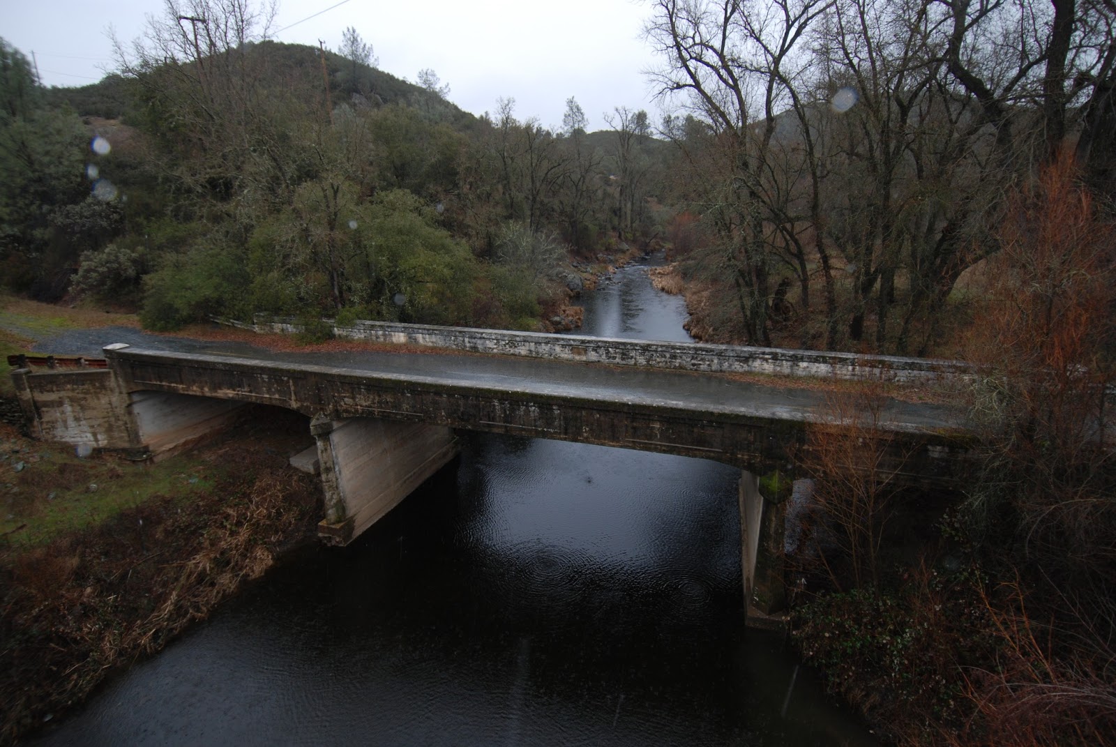
C: Green Valley Road Bridge, a concrete T girder bridge built in 1926 (shown on 2/21).
D1: The New State Route 50 Bridges, steel stringer bridges built in 1963 (shown from 2/11 to 2/13).
D2: The Old State Route 50 Bridge, a concrete T girder bridge built in 1938 (shown 2/11 to 2/13).
E: Forni Road Bridge, a three span concrete open spandrel arch built in 1914 (shown from 2/8 to 2/10).
F: The Southern Pacific Railroad Viaduct built in 1903 (shown from 2/14 to 2/16).
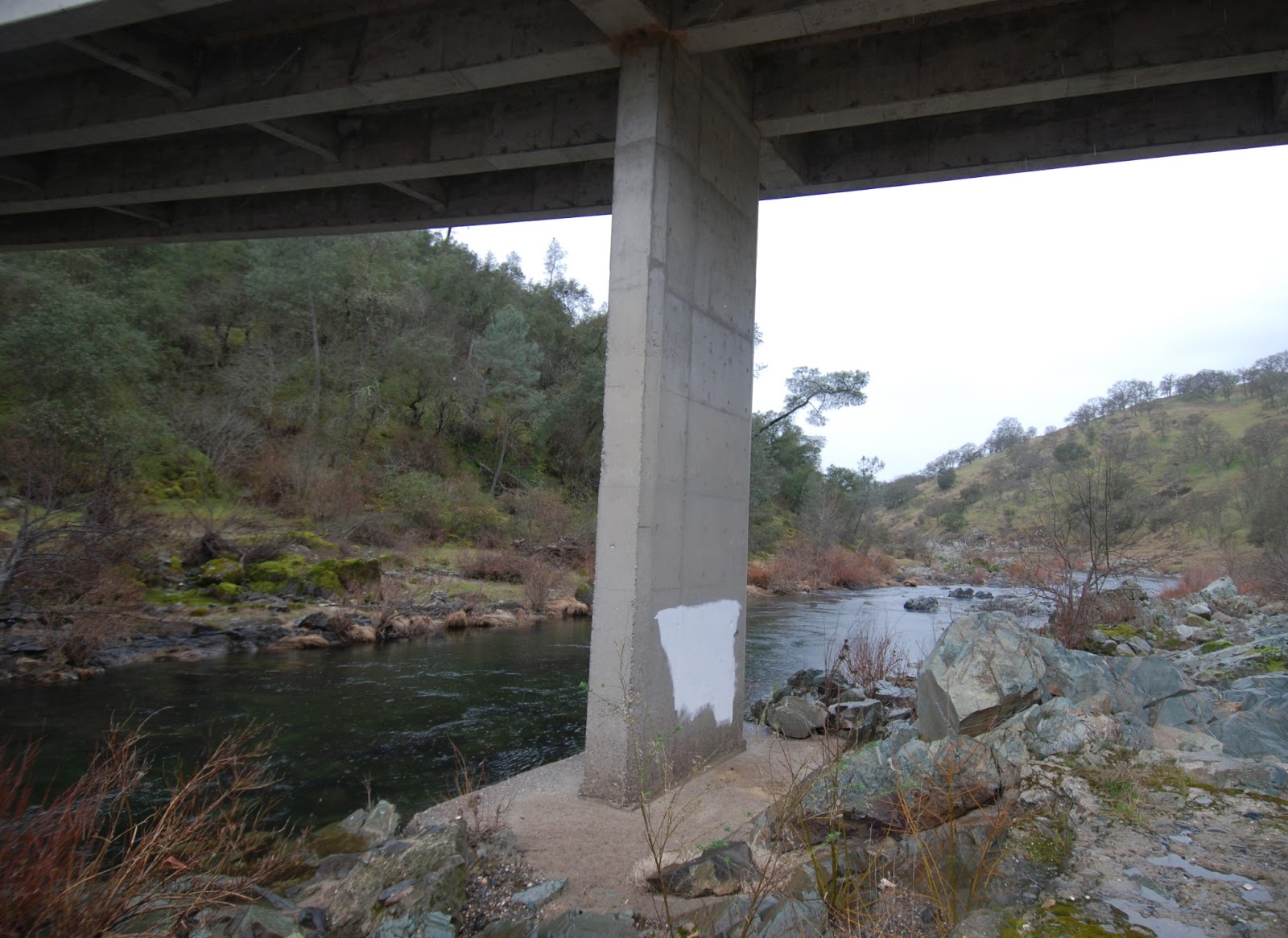
G: The State Route 49 Bridge, a one span concrete box girder bridge built in 1963 (shown on 2/17).
H: Big Cut Road Bridge a two span concrete T girder bridge built in 1922 (shown on 2/18).
I: Cedar Ravine Road Bridge, a single span concrete slab bridge built in 1930 (shown on 2/19).
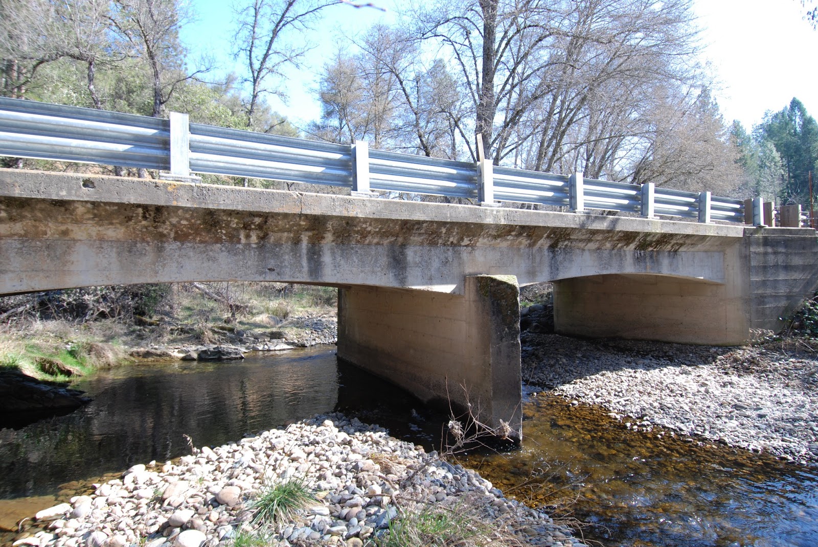
J: The Newton Road Bridge, a small concrete slab bridge built in 1929 (shown on 2/20).
That's a lot of bridges for such a tiny creek. The much wider South Fork of the American River north of Weber Creek (that we previously studied) has far fewer bridges, probably because its more expensive to cross.

Friday, February 22, 2013

El Dorado County, California Bridges: Lotus Road Bridges across Weber Creek

February 2013 (38.7399 Degrees, -120.9339 Degrees) Lotus Road Bridges
There is a rather pretty older slab bridge (now closed) and a modern box girder bridge that both cross Weber Creek at Lotus Road. The open bridge is a two span river crossing on seat-type abutments and a single pier wall that was built in 1987. The closed bridge is behind the fence of the Sierra Rock Quarry. It sits on big pier walls and abutments all covered in moss, which was the result of 90 years of floods. You can see in the photo that the new bridge is much taller and also much cleaner.
Creative Commons License
El Dorado County, California Bridges: Lotus Road Bridges across Weber Creek by Mark Yashinsky is licensed under a Creative Commons Attribution-NonCommercial-ShareAlike 3.0 United States License.

Thursday, February 21, 2013

El Dorado County, California Bridges: Green Valley Road Bridge across Weber Creek

February 2013 (38.7224 Degrees,  -120.8452 Degrees) Green Valley Road Bridge
The last couple of bridges in this series of blogs are near the mouth of Weber Creek.

The Green Valley Bridge is a 100 ft long single span reinforced concrete T girder bridge built in 1926. We are in the Placerville/Diamond Springs area, which must have been growing in the 1920s and reinforced concrete was the material of choice for their river crossings. Like yesterday's Newtown Road Bridge, this single span structure has haunches at the abutments and nice formwork that includes slight recesses in the girders.

Unfortunately, I climbed right down the riverbank, which was covered in blackberry and poison oak, to take this photo.
Creative Commons License
El Dorado County, California Bridges: Green Valley Road Bridge across Weber Creek by Mark Yashinsky is licensed under a Creative Commons Attribution-NonCommercial-ShareAlike 3.0 United States License.

Wednesday, February 20, 2013

El Dorado County, California Bridges: Newtown Road Bridge across Weber Creek

February 2013 (38.7148 Degrees, -120.71397 Degrees) Newtown Road Bridge
The next bridge (which is also the first bridge that crosses Weber Creek) is a 30 ft long concrete slab built in 1929 that carries Newtown Road just west of the Weber Creek Reservoir. Like the previous bridge it has nice use of formwork for the slight haunch at the abutment walls and for the recessed panels on the barrier rails.
Creative Commons License
El Dorado County, California Bridges: Newtown Road Bridges across Weber Creek by Mark Yashinsky is licensed under a Creative Commons Attribution-NonCommercial-ShareAlike 3.0 United States License.

Tuesday, February 19, 2013

El Dorado County, California Bridges: Cedar Ravine Rd Bridge across Weber Creek

February 2013 (38.7076 Degrees, -120.7635 Degrees) Cedar Ravine Bridge
The next bridge continuing upstream on Weber Creek was so small that we almost drove past it, but it's another example of the care taken in building these early 20th century reinforced concrete bridges. The formwork was carefully made to provide a cap, a curb, and other details on the massive barriers. The slab is nicely framed into the abutments. The engineer and contractor were so proud of their work that they embedded a plaque in the wall with their names (Henry Lahiff and H. Williamson). The lesson is that no job is too small that it can't benefit from special attention.
Creative Commons License
El Dorado County, California Bridges: Cedar Ravine Rd Bridge across Weber Creek by Mark Yashinsky is licensed under a Creative Commons Attribution-NonCommercial-ShareAlike 3.0 United States License.

Monday, February 18, 2013

El Dorado County, California Bridges: Big Cut Rd across Weber Creek

February 2013 (38.70425 Degrees, -120.79509 Degrees) Big Cut Road Bridge
Continuing upstream on Weber Creek from State Route 49 to Big Cut Road is this old but still handsome two span T girder bridge (25C0076). The center pier that supports the girders has sharp cutwaters both up and down stream, suggesting that this little creek can sometimes overtop the deck.
 Strangely, the pier wall doesn't extend all the way up to the soffit. Instead, the T beams drop down with fillets that are developed into the pier wall. It's an interesting design and it must work since the bridge has withstood the test of time.
The formwork was well put together on this bridge. The deck overhang flares out nicely from the exterior girders, which are carefully framed into the diaphragm abutments. The slight haunch of the exterior girders is another pleasant touch.
Although the bridge appears in pretty good shape, something is wrong with the deck. The concrete is spalling at the ends of the bridge and there is an odd strip-like pattern suggesting the entire deck is delaminated from the girders. Probably a concrete deck overlay was poured later but the existing surface wasn't raked properly or there's some other problem.

The bridge was built in 1922, which makes it 91 years old and eligible for the Register of Historical Places, although there is no mention in the inspection report of protecting this handsome older bridge. It's two spans are 23 ft long for a total length of 48 feet (including the backwalls).
Creative Commons License
El Dorado County, California Bridges: Big Cut Rd across Weber Creek by Mark Yashinsky is licensed under a Creative Commons Attribution-NonCommercial-ShareAlike 3.0 United States License.

Sunday, February 17, 2013

El Dorado, California Bridges: Route 49 Bridge across Weber Creek

February 2013 (38.708 Degrees, -120.812 Degrees) Route 49 Bridge
The next bridge over Weber Creek is a one span reinforced concrete box girder structure that carries State Route 49. It's strange that a 110 year old railway viaduct, a 99 year old arch bridge, a 75 year old haunched girder highway bridge, a modern highway bridge, and this tiny structure were all built to cross the same creek within a few miles of each other.

The State Route 49 bridge over Weber Creek is 27.7 m (91 ft) long and it was built in 1967.
Creative Commons License
El Dorado, California Bridges: Route 49 Bridge across Weber Creek by Mark Yashinsky is licensed under a Creative Commons Attribution-NonCommercial-ShareAlike 3.0 United States License.

Saturday, February 16, 2013

El Dorado County, California Bridges: Southern Pacific Viaduct across Weber Creek (3)

February 2013 (38.7084 Degrees, -120.8136 Degrees) Southern Pacific Viaduct
A view of the approach to the Southern Pacific Railway Viaduct which was converted to part of a hiking trail. The Sacramento-Placerville Transportation Corridor (SPTC) Joint Powers Authority purchased the Sacramento-Placerville railroad corridor from the Southern Pacific Railway Corporation in 1991. The 28 mile long segment of the SPTC in El Dorado County extends from Latrobe in the west to Placerville. More information on the trail is available from the SPTC-JPA.
The El Dorado Trail was designated a Millennium Trail by Hillary Clinton in 2000 and there are plans to make it a multi-modal transportation corridor that extends from the western border of El Dorado County all the way to South Lake Tahoe. In 2010, the trestle segment of this trail was awarded the ASCE 2009 History and Heritage Project of the Year.
Creative Commons License
El Dorado County, California Bridges: Southern Pacific Viaduct across Weber Creek (3) by Mark Yashinsky is licensed under a Creative Commons Attribution-NonCommercial-ShareAlike 3.0 United States License.

Friday, February 15, 2013

El Dorado County, California Bridges: Southern Pacific Viaduct across Weber Creek (2)

February 2013 (38.7084 Degrees, -120.8136 Degrees) Southern Pacific Viaduct
A closer look at the towers on the Southern Pacific Viaduct over Weber Creek. The bridge is stamped with a date of 1903, making it 110 years old. That was the date when the Camino, Placerville, and Lake Tahoe (CPLT) Shortline Railroad was built to haul lumber out of the El Dorado National Forest.  The history of the railway can be found on this Wikepedia Website

The CPLT was owned by the Michigan-California Lumber Company. In 1986 the Southern Pacific abandoned the Placerville Branch, eliminating the CPLT's access to a national rail network. Scrapping of the CPLT began in 1986, but fortunately, they didn't scrap this enormous viaduct, which besides a little rust seems as good as new.
Creative Commons License
El Dorado County, California Bridges: Southern Pacific Viaduct across Weber Creek (2) by Mark Yashinsky is licensed under a Creative Commons Attribution-NonCommercial-ShareAlike 3.0 United States License.

Thursday, February 14, 2013

El Dorado County, California Bridges: Southern Pacific Viaduct across Weber Creek (1)

February 2013 (38.7084 Degrees, -120.8136 Degrees) Southern Pacific Viaduct
The next bridge over Weber Creek is southeast of the Forni Road Bridge. It's an old railroad viaduct that was once part of a branch line that extended from Sacramento to Placerville. The line was abandoned and eventually turned into the El Dorado Trail, a 28 mile long bike, foot, and horse path between Shingle Springs in the west to Camino in the east.

It's interesting how little Weber Creek eventually created such a huge valley that needed to be crossed by such a tall viaduct. A railroad bridge needs to be longer and therefore taller than a highway bridge to avoid steep grades, which explain why this viaduct is even taller than the State Route 50 Bridges that we've been studying over the past few days.
We'll take a closer look at the viaduct and trail tomorrow.
Creative Commons License
El Dorado County, California Bridges: Southern Pacific Viaduct across Weber Creek (1) by Mark Yashinsky is licensed under a Creative Commons Attribution-NonCommercial-ShareAlike 3.0 United States License.

Wednesday, February 13, 2013

El Dorado County, California's Bridges: State Route 50 across Weber Creek (3)

February 2013 (38.71669 Degrees, -120.8362 Degrees) Weber Creek Bridge
A last few photos of the old and new State Route 50 Bridges across Weber Creek. I scrambled through heavy brush to get this photo, but I'm a little paranoid of riparian vegetation since I got a severe poison oak rash recently. Nothing helped until I finally got my doctor to prescribe some Prednisone, which really works.
This bridge reminds me of the Forni Road Bridge across Weber Creek that we previously studied since it's pretty much of a slab bridge with supports at the sides. However, this bridge has more diaphragms, which the Forno Road Bridge was able to do without. Another strange thing is the building paper falling out of the expansion joints. It seems strange that paper would still be coming out of a 75 year old bridge.

Well, this old bridge presents more questions than answers. Perhaps someone familiar with the old highway can enlighten us?
Creative Commons License
El Dorado County, California's Bridges: State Route 50 across Weber Creek (3) by Mark Yashinsky is licensed under a Creative Commons Attribution-NonCommercial-ShareAlike 3.0 United States License.

Tuesday, February 12, 2013

El Dorado County, California's Bridges: State Route 50 across Weber Creek (2)

February 2013 (38.71669 Degrees, -120.8362 Degrees) Weber Creek Bridge
In the photo above we can see how the old State Route 50 Bridge over Weber Creek is dwarfed by the newer highway bridges. It looks like the newer bridges are on taller embankments, perhaps because they are raised above the 100 year flood (or maybe they are just longer and going over a deep valley).
The old State Route 50 Bridge is a five span haunched girder bridge with in-span hinges at the first and fifth spans. I think the bridge might have been rehabilitated at some point. Note the interesting roller bearings in the photo below. Those don't look like they were built in 1938. The bridge is now 75 years old, which makes it eligible for designation as an historic place. However, I couldn't find any reference to this bridge. It looks like a new end diaphragm and new wingwall (and perhaps a new abutment) were cast recently, perhaps because of the widening of the newer bridges?
Creative Commons License
El Dorado County, California's Bridges: State Route 50 across Weber Creek (2) by Mark Yashinsky is licensed under a Creative Commons Attribution-NonCommercial-ShareAlike 3.0 United States License.