Thursday, June 30, 2011

New Zealand's Bridges: Mona Vale Garden Bridges across the Avon River in Christchurch (4)

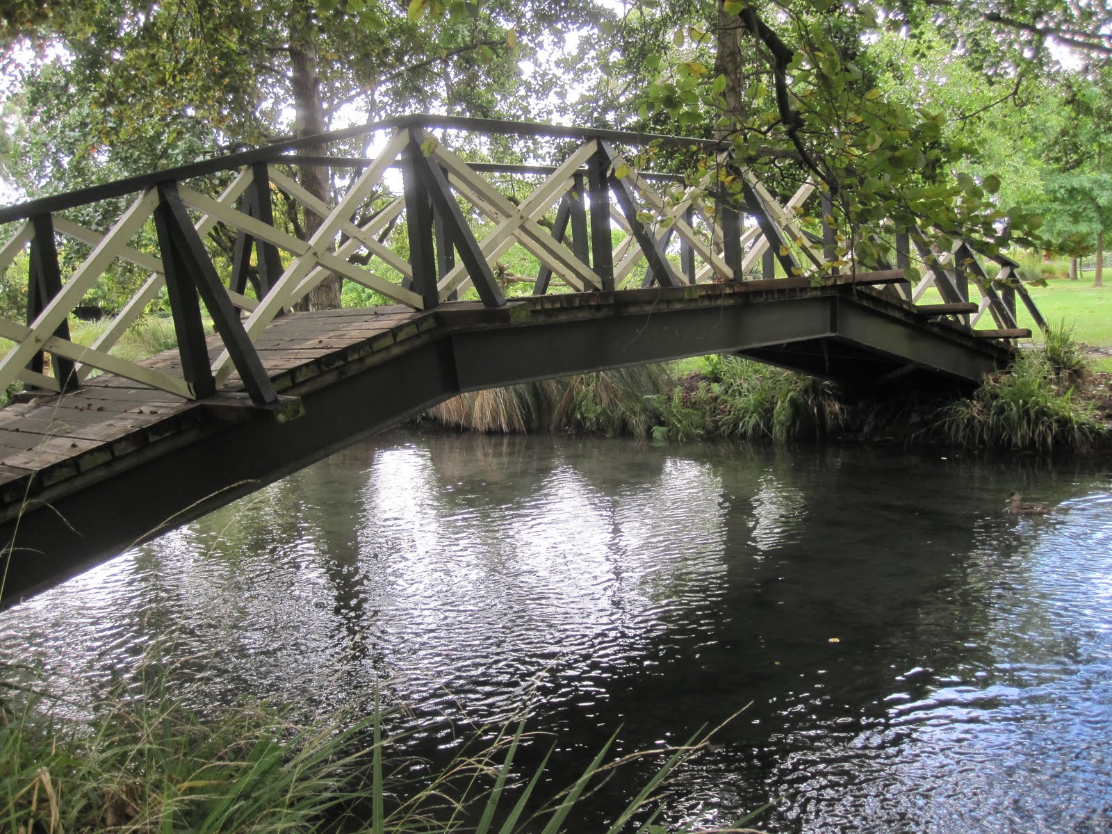
March 2011 (-43.523 Degrees, 172.609 Degrees) Mono Vale Garden Bridge
We are just west of Christchurch's Central Business District in the affluent residential communities of Riccarton and Fendalton and especially Mona Vale, where this lovely Park sits.

We had previously looked at a profile view of this garden bridge but I wanted to show the timber deck. I thought it was nice that they provide planking in the direction of travel to protect the lower deck and structural elements from the wear and tear of vehicular traffic.

The Park was closed when I visited. Retreating glaciers from the last ice age had deposited loose saturated sands through the region that had liquefied during the earthquake, damaging buildings and bridges in the park and in the city (although this bridge remained open).

The residents of Christchurch were required to remove the ejected soil on their property as a first step in the recovery. People spoke of their 'bit of liquefaction' that had to be placed on the curb for pickup. Probably an attempt for people to feel back in control of their lives. Still, portable latrines stood at every street corner since water and sewer lines had been broken.
Creative Commons License
New Zealand's Bridges: Mona Vale Garden Bridges across the River Avon in Christchurch (4) by Mark Yashinsky is licensed under a Creative Commons Attribution-NonCommercial-NoDerivs 3.0 Unported License.

Wednesday, June 29, 2011

New Zealand's Bridges: Mona Vale Garden Bridges across the River Avon in Christchurch (3)

March 2011 (-43.523 Degrees, 172.609 Degrees) Mono Vale Garden Bridge
I read that it should actually be called the Avon River (not the River Avon as I had been calling it) and that it is (or was) called the Otakaro by the Maori. I was surprised that it is only 14 km long (despite quite a bit of meandering) from Avonhead in the west out through the Heathcote Estuary into the Pacific.

Here is still another handsome bridge (with quite a bit of camber)  across the river in Mona Vale Park just a little west of the Christchurch CBD. The bridge has a gate at both ends, which were closed when I was there, because the entire park (as well as most of Christchurch) had suffered quite a bit of liquefaction during the recent earthquake.
Creative Commons License
New Zealand's Bridges: Mona Vale Garden Bridges across the River Avon in Christchurch (3) by Mark Yashinsky is licensed under a Creative Commons Attribution-NonCommercial-NoDerivs 3.0 Unported License.

Tuesday, June 28, 2011

New Zealand's Bridges: Mona Vale Garden Bridges across the River Avon in Christchurch (2)

March 2011 (-43.523 Degrees, 172.609 Degrees) Mono Vale Garden Bridge


Another Garden Bridge in Mona Vale Park. All of these bridges have nice timber railings and a kind of faux arch shape. However, this bridge has a real arch since the two ends have sloping steel girders that put the superstructure into compression and make the span longer. All of them were closed when I took these photos due to lateral spreading at the approaches. 


The river meanders through the park, perhaps by nature or possibly through human interference. I can imagine small parties of wedding guests sipping champagne in gowns and suits and sauntering across the half-dozen bridges before and after the ceremony.
Creative Commons License
New Zealand's Bridges: Mona Vale Garden Bridges across the River Avon in Christchurch (2) by Mark Yashinsky is licensed under a Creative Commons Attribution-NonCommercial-NoDerivs 3.0 Unported License.

Monday, June 27, 2011

New Zealand's Bridges: Mona Vale Garden Bridges across the River Avon in Christchurch (1)

March 2011 (-43.523 Degrees, 172.609 Degrees) Mono Vale Garden Bridge
It turned out that I had started my exploration of River Avon bridges a little further to the west than I had at first imagined. There are half a dozen handsome bridges in Mona Vale Park, about 1.5 km east of the Helmores Lane Bridge. All of these little bridges are quite lovely. The park was used by couples wishing to be married and I think there may also be music and theater there. When I was there, it was closed (as was most of Christchurch) by the earthquake, but hopefully it has since reopened (I had to get a special badge to be allowed into Christchurch). 

I don't have my notes with me, but I wonder if this isn't one of those steel stringer bridges masquerading as an arch with a handsome facade? The ever helpful Geoffrey Thornton (author of 'Bridging the Gap, Early New Zealand Bridges') confirmed my suspicion, and included a photo of the same structure, which he calls a garden bridge. The railing is quite nice, almost Art Nouveau in style, or at least attractive enough to be in a painting of a Pre-Raphaelite woman staring Ophelia-like into the waters below.
Creative Commons License
New Zealand's Bridges: Mona Vale Garden Bridges across the River Avon in Christchurch (1) by Mark Yashinsky is licensed under a Creative Commons Attribution-NonCommercial-NoDerivs 3.0 Unported License.

Sunday, June 26, 2011

New Zealand's Bridges: Helmores Lane Bridge across the River Avon in Christchurch

March 2011 (-43.532 Degrees, 172.622 Degrees) Helmores Lane Bridge


The River Avon runs easterly through the town of Christchurch before emptying into the Pacific. We are starting our journey down the Avon in a vast green area in western Christchurch that includes parks and botanical gardens. 

This three span timber bridge carries vehicular traffic and with its rough hewn timber piers and diagonal supports it reminds me a little of the bridge they built for the film 'Bridge on the River Kwai.' 

I was surprised to find a reference to it in Structurae. It was apparently designed by Joseph Cornish Helmore in 1864 making it one of the earliest bridges still in use in New Zealand. There is even a book written about early New Zealand Bridges, 'Bridging the Gap,' by Thornton Geoffrey that includes a photo and a description of the bridge.   


Hopefully this bridge, which was badly damaged and closed to traffic after the recent earthquake, has been repaired.


Creative Commons License
New Zealand's Bridges: Helmores Lane Bridge across the River Avon in Christchurch by Mark Yashinsky is licensed under a Creative Commons Attribution-NonCommercial-NoDerivs 3.0 Unported License.

Saturday, June 25, 2011

Japan's Bridges: Shibaura Canal Bridge in Minato Ward, Tokyo

June 2011 (35.642 Degrees, 139.746 Degrees) Shibaura Canal Bridge


One of the nice things about Tokyo are all the lovely walkways along the canals that run through the city. The Japanese are wonderful gardeners and so these paths are surrounded with well-manicured flowers, trees, and shrubs.


An emperor had decreed that an inland canal should be built just west of the Pacific to allow for the transport of goods (similar to the Intercoastal Waterway in the U.S.). I'm not sure if the canal in this photo is part of the emperor's waterway or if it was created by the many islands being built in Tokyo Bay to house it's growing population. 


The red building behind the bridge is the hotel where we stayed during our last week in Japan. The Japan Society of Civil Engineers had somehow negotiated a price of about $100 a day to stay there. Minato Ward is a maze of canals crossed by hundreds of little bridges including this fantastically-ornamented structure, that may have taken inspiration from all the blossoms that surround it.
Creative Commons License
Japan's Bridges: Shibaura Canal Bridge in Minato Ward, Tokyo by Mark Yashinsky is licensed under a Creative Commons Attribution-NonCommercial-NoDerivs 3.0 Unported License.

Friday, June 24, 2011

Japan's Bridges: Tokyo Gate Bridge (東京ゲートブリッジ) In Tokyo Bay

June 2011 ( 35.611 Degrees, 139.826 Degrees) Tokyo Gate Bridge
Today we visited a new bridge being built in Tokyo Bay. Because of traffic into Tokyo Port it had to have a vertical clearance of about 55 m. Because it's next to Haneda Airport it had to be less than 88 m tall. The unique shape with the truss staggered under and over the deck was the solution adopted by Japan's Ministry of Land Infrastructure and Transportation to provide a bridge across Tokyo Bay with a 440 m main span meeting those requirements.

The truss sections were fabricated in Osaka and carried to Tokyo by barge. Unfortunately, a typhoon caused some damage to one of the sections as it was entering Tokyo Bay. Each truss segment weighed about 7000 tons, and required a fleet of floating cranes to lift onto the piers.

Because of it's unusual shape the bridge has the nickname of 'Dinosaur Bridge.' It's scheduled for completion in October. When we were there, they were getting ready to put a riding surface onto the steel deck.
Creative Commons License
Japan's Bridges: Tokyo Gate Bridge (東京ゲートブリッジ) In Tokyo Bay by Mark Yashinsky is licensed under a Creative Commons Attribution-NonCommercial-NoDerivs 3.0 Unported License.

Thursday, June 23, 2011

Japan's Bridges: Rokugo Railway Bridges across the Tamagawa in Tokyo

June 2011 (35.537 Degrees, 139.703 Degrees) Rokugo Bridges
Although Tokyo is a densely populated city, it is a very pleasant and livable place because of it's excellent railway network. No matter where you are in Tokyo, you are always near a train station and you can quickly get anywhere in the large metropolitan area.

For instance, despite staying near Tokyo Bay, today I was kayaking in the Tamagawa after a half hour train ride. And bridge aficionados can enjoy the hundreds of bridges and viaducts required for the various railway lines.
Creative Commons License
Japan's Bridges: Rokugo Railway Bridges across the Tamagawa in Tokyo by Mark Yashinsky is licensed under a Creative Commons Attribution-NonCommercial-NoDerivs 3.0 Unported License.

Wednesday, June 22, 2011

Japan's Bridges: Rainbow Bridge across Tokyo Bay

June 2011 (35.628 Degrees, 139.774 Degrees) Rainbow Bridge
I've included several photo's of Tokyo's Rainbow bridge in the past, but this is the first time that I've included the Statue of Liberty. I went to Odaiba in Tokyo Bay to buy a ticket for the ferry that goes up the Arakawa River. However, the concessionaire told me that the Arakawa was too rough for the ferry at this time. The trip wasn't a complete waste of time because I found the Statue of Liberty (with her back to the Rainbow Bridge).

Creative Commons License
Japan's Bridges: Rainbow Bridge across Tokyo Bay by Mark Yashinsky is licensed under a Creative Commons Attribution-NonCommercial-NoDerivs 3.0 Unported License.

Tuesday, June 21, 2011

Japan's Bridges: St Luke's Towers Skybridge in Tokyo

June 2011 (35.6667 Degrees, 139.7793 Degrees) St Luke's Towers Skybridge
Coincidentally, The Happy Pontist published a post about building to building bridges right after I wrote this blog. The photo was taken from a ferry on the Sumida River in Tokyo. The two buildings are called St. Luke's Towers (or Seiroka Towers). According to the Emporius Website, this 'skybridge' is 24 meters long and the system can expand and contract up to two meters for high winds or earthquakes.
Creative Commons License
Japan's Bridges: St. Luke's Towers Skybridge in Tokyo by Mark Yashinsky is licensed under a Creative Commons Attribution-NonCommercial-NoDerivs 3.0 Unported License.

Monday, June 20, 2011

Japan's Bridges: Hokosugi Bridge in Omiya

June 2011 (35.896 Degrees, 139.631) Hokosugi Bridge
On the Shinkansen from Sendai to Tokyo I photographed this basket-handle arch bridge as the train passed through Omiya.
Creative Commons License
Japan's Bridges: Hokosugi Bridge in Omiya by Mark Yashinsky is licensed under a Creative Commons Attribution-NonCommercial-NoDerivs 3.0 Unported License.

Sunday, June 19, 2011

Japan's Bridges: Kouzaki Bridges across Tonegawa in Ibaraki

June 2011 (35.9105 Degrees 140.396 Degrees) Kouzaki Bridges

Today we went to Ibaraki Prefecture to look at bridge damage from the March 11, 2011 Tohoku Earthquake. Japan is divided into prefectures like Ibaraki and also into regions like Kanto, Kansai, and Tohoku, which is in northeast Honshu (one of the four islands in Japan).

The Kousaki Bridges had minor damage from an earthquake that stretched 700 km from Iwate Prefecture in the northeast to Chiba Prefecture in the southwest.  The bridges were open for two months and then an engineer discovered some of the piles were broken (due to lateral spreading) and closed the highway bridge (the pedestrian bridge remains open).
Creative Commons License
Japan's Bridges: Kouzaki Bridges across Tonegawa in Ibaraki by Mark Yashinsky is licensed under a Creative Commons Attribution-NonCommercial-NoDerivs 3.0 Unported License.

Saturday, June 18, 2011

Japan's Bridges: Imagawa Bridge across the Sakai River in Chiba

June 2011 (35.647 Degrees, 139.909 Degrees) Imagawa Bridge

There are so many nice bridges in Japan and in such nice colors!  We were driving through Urayasu looking at liquefaction damage (mostly removed) when I shot this photo of the Imagawa Bridge across the Sakai River. It's a steel tied arch with wide flange hangers and a few cross-braces. Behind it is a Shinkansen bridge and there's a pretty utility bridge in front (out of the photo). 
Creative Commons License
Japan's Bridges: Imagawa Bridge across the Sakai River in Chiba by Mark Yashinsky is licensed under a Creative Commons Attribution-NonCommercial-NoDerivs 3.0 Unported License.

Friday, June 17, 2011

Japan's Bridges: Hiyori Bridge across the Kitakami River in Ishinomaki (2)

June 2011 (38.415 Degrees, 141.312 Degrees) Miyori-Ohashi
This bridge was recently retrofitted with steel jackets around the columns and restrainers and shear keys at the bearings. However, the superstructure is high enough to have avoided the tsunami rushing upstream after the earthquake.

The one thing I'm uncertain about is the use of Corten (weathering) steel for the girders. I wonder if this type of steel performs as well and lasts as long as steel girders that are primed and periodically painted?

Creative Commons License
Japan's Bridges: Hiyori Bridge across the Kitakami River in Ishinomaki (2) by Mark Yashinsky is licensed under a Creative Commons Attribution-NonCommercial-NoDerivs 3.0 Unported License.

Thursday, June 16, 2011

Japan's Bridges: Hiyori Bridge across the Kitakami River in Ishinomaki (1)

June 2011 (38.415 Degrees, 141.312 Degrees) Miyori-Ohashi
Standing on a hill looking down at the tsunami-devastated town of Ishinomaki, Japan. However, the recently retrofitted Hiyori Bridge is undamaged. It's a haunched steel box girder bridge across the mouth of the Kitakami River. We'll take a closer look at it tomorrow.

Creative Commons License
Japan's Bridges: Hiyori Bridge across the Kitakami River in Ishinomaki (1) by Mark Yashinsky is licensed under a Creative Commons Attribution-NonCommercial-NoDerivs 3.0 Unported License.

Wednesday, June 15, 2011

Japan's Bridges: Pedestrian Overcrossing near train station in Sendai

June 2011 (38.259 degrees, 140.881 degrees) Pedestrian Overcrossing near Sendai Train Station


This overcrossing in downtown Sendai provides pedestrians with access to all corners of an intersection as well as for a couple of different streets. Note the very deep girders needed on this interesting structure. The pedestrian loading on a bridge is higher than an HS15 truck for some reason.
Creative Commons License
Japan's Bridges: Pedestrian Overcrossing near train station in Sendai by Mark Yashinsky is licensed under a Creative Commons Attribution-NonCommercial-NoDerivs 3.0 Unported License.

Tuesday, June 14, 2011

Japan's Bridges: Fukumuro Overcrossings in Sendai

June 2011 (38.275 degrees, 140.973 degrees) Fukumuro Overcrossings

I photographed these bridges on the way to a meeting at the Port of Sendai. They include a highway bridge over Japan Railway tracks and Route 45 and a pedestrian bridge that just crosses over the railroad. The POC is steel while the road bridge is concrete and they're both supported by concrete hammerhead bents. Both bridges are long because the ends are at grade while the main spans are 25 feet above the railway.
Creative Commons License
Japan's Bridges: Fukumuro Overcrossings in Sendai by Mark Yashinsky is licensed under a Creative Commons Attribution-NonCommercial-NoDerivs 3.0 Unported License.

Monday, June 13, 2011

Japan's Bridges: Railway Bridges in Sendai

June 2011 (38.2552 degrees, 140.8836 degrees) Sendai Railway Bridges

Greetings from Sendai, Japan. Today's photo is of two railroad bridges next to my hotel. The higher one is a concrete box girder bridge for Shinkansen and the lower one is a steel girder bridge for regular trains. These bridges were undamaged from the recent earthquake, but there was little ground shaking damage to bridges in general and I'm six miles from the coast where the tsunami damage occurred.
Creative Commons License
Japan's Bridges: Railway Bridges in Sendai by Mark Yashinsky is licensed under a Creative Commons Attribution-NonCommercial-NoDerivs 3.0 Unported License.

Sunday, June 12, 2011

California's Bridges: Golden Gate Bridge in San Francisco Bay (6)

1999 (37.818 deg, -122.478 deg.) Golden Gate Bridge

A statue of Joseph Strauss, who is credited with getting a bridge built across the Golden Gate. The design of the bridge is now credited to Charles Ellis. Construction was done by McClintic and Marshall. However, Strauss was the driving force that got the project approved and built.
Creative Commons License
California's Bridges: Golden Gate Bridge in San Francisco Bay (6) by Mark Yashinsky is licensed under a Creative Commons Attribution-NonCommercial-NoDerivs 3.0 Unported License.

Saturday, June 11, 2011

California's Bridges: Golden Gate Bridge in San Francisco Bay (5)

1987 (37.818 deg, -122.478 deg.) Golden Gate Bridge

A photo of my younger daughter and myself on the Golden Gate Bridge. The bridge has three northbound lanes and three southbound lanes. Today, they quickly re-stripe the lanes to allow four lanes of southbound traffic in the morning and four lanes northbound traffic in the evening. Tolls are six dollars if you use the booth or five dollars if you use electronic tracking. Pedestrians and bicyclists can use the bridge for free.
Creative Commons License
California's Bridges: Golden Gate Bridge in San Francisco Bay (5) by Mark Yashinsky is licensed under a Creative Commons Attribution-NonCommercial-NoDerivs 3.0 Unported License.

Friday, June 10, 2011

California's Bridges: Golden Gate Bridge in San Francisco Bay (4)

1987 (37.818 deg, -122.478 deg.) Golden Gate Bridge

A photo (taken 24 years ago) of my oldest daughter standing on the deck of the Golden Gate Bridge. The modular deck and sidewalk were laid onto the floor beams about a year earlier. The sidewalk looks different today because of all the bicyclists and because they put a tall rail between the sidewalks and the roadway. There are also elaborate rules about when bicyclists and pedestrians can use the east and west sidewalks.
Creative Commons License
California's Bridges: Golden Gate Bridge in San Francisco Bay (4) by Mark Yashinsky is licensed under a Creative Commons Attribution-NonCommercial-NoDerivs 3.0 Unported License.

Thursday, June 9, 2011

California's Bridges: Golden Gate Bridge in San Francisco Bay (3)

1987 (37.818 deg, -122.478 deg.) Golden Gate Bridge

Mark Twain apparently never said that the coldest winter he ever spent was a summer in San Francisco. However, the sentiment nonetheless rings true. This photo, taken more than twenty years ago, shows my daughter's enjoying a pleasant summer's day by the Golden Gate Bridge. 

Walking on the Golden Gate Bridge, I often see dense clouds sitting just outside the Golden Gate while the sun is shining in the Bay. After the 1989 Loma Prieta earthquake, I volunteered to work on the repairs of the Bay Bridge (in late October). I spent a month on the bridge, but I could never get warm, despite having grown up in Michigan.
Creative Commons License
California's Bridges: Golden Gate Bridge in San Francisco Bay (3) by Mark Yashinsky is licensed under a Creative Commons Attribution-NonCommercial-NoDerivs 3.0 Unported License.

Wednesday, June 8, 2011

California's Bridges: Golden Gate Bridge in San Francisco Bay (2)

1999 (37.818 deg, -122.478 deg.) Golden Gate Bridge
The Golden Gate Bridge includes a park where people can enjoy views of the Bay. When I first started at Caltrans, a new deck was being installed (by Caltrans for some reason). An engineer in my design section had worked on the deck replacement which was being done at night. He told me that several times a week, someone would drive onto the bridge and slam on the brakes. Then the driver would run out of the car and throw themselves off the bridge. I can hardly imagine what that must feel like, except that it must feel really awful.
Creative Commons License
California's Bridges: Golden Gate Bridge in San Francisco Bay (2) by Mark Yashinsky is licensed under a Creative Commons Attribution-NonCommercial-NoDerivs 3.0 Unported License.

Tuesday, June 7, 2011

California's Bridges: Golden Gate Bridge in San Francisco Bay (1)

1999 (37.818 deg, -122.478 deg.) Golden Gate Bridge
The Golden Gate Bridge is a suspension bridge built in 1937 with a 4200 ft long main span. It carries traffic between the City of San Francisco and Marin County over a narrow strait where San Francisco Bay empties into the Pacific. It's the only toll bridge in San Francisco Bay that is not owned and managed by Caltrans. Instead, it is owned by the Golden Gate Bridge Highway and Transportation District, whose responsibilities extend to the single bridge that towers over their headquarters.
Creative Commons License
California's Bridges: Golden Gate Bridge in San Francisco Bay (1) by Mark Yashinsky is licensed under a Creative Commons Attribution-NonCommercial-NoDerivs 3.0 Unported License.

Sunday, June 5, 2011

California's Bridges: Benicia-Martinez Bridges across the Carquinez Straits (5)

1999 (38.043 deg, -122.122 deg.) Benicia-Martinez Bridges

Well, this is my best photo of the Benicia-Martinez Railway Bridge (owned by the Union Pacific Railroad). You can see that this photo was taken before the segmentally-constructed highway bridge was built to the east. Its amazing that this old railway bridge (from 1930) stands between an expensively retrofit and an expensive new highway bridge. The railroads are run by a tough bunch of business-people who guard their rights zealously. Whenever we want to build anything near their right-of-way they drive a very hard bargain.


Despite its fragile appearance, the railway bridge does carry a couple dozen trains every day. I do recall the railway bridge had some damage from the 1989 Loma Prieta earthquake. I believe there is a lift span at the center of the bridge, but I can't recall if it ever is opened.
Creative Commons License
California's Bridges: Benicia-Martinez Bridges across the Carquinez Straits (5) by Mark Yashinsky is licensed under a Creative Commons Attribution-NonCommercial-NoDerivs 3.0 Unported License.