Saturday, May 31, 2014

Santa Clara County, California Bridges: Caltrain Bridge across San Francisquito Creek

May 2014 (37.44725 Degrees-122.17039 Degrees) Caltrain Bridge
The last structure I photographed in Santa Clara County was an old railroad bridge next to Stanford University (there are other Santa Clara County bridges to the south that we'll get at some later time).
The Caltrain Bridge across San Francisquito Creek is a single span, five panel truss bridge with half-hipped members to strengthen what would otherwise be a simple Pratt truss. If I had to guess, I would call this a Baltimore truss with the half-hipped members to prevent buckling of the heavily-loaded compression members. This bridge was built in 1902, it's 104 ft long, 30 ft wide, and carries two sets of tracks. Note the big gusset plates that hold all of the truss members together (in the photo below).
Creative Commons License
Santa Clara County, California Bridges: Caltrain Bridge across San Francisquito Creek by Mark Yashinsky is licensed under a Creative Commons Attribution-NonCommercial-NoDerivatives 4.0 International License.

Friday, May 30, 2014

Santa Clara County, California Bridges: El Camino Real Bridge across Adobe Creek

May 2014 (37.40629 Degrees, -122.12012 Degrees) Adobe Creek Bridge
We'll finish our survey of Santa Clara County with a few bridges in Palo Alto, the community that surrounds Stanford University. The Adobe Creek Bridge (37 0661) is called an arch but it's really just a culvert under El Camino Real (CA 82) Highway. It's 20 ft long and it was built in 2004. Perhaps it replaced an arch bridge or possibly the arch bridge is now hidden behind a road widening.
Creative Commons License
Santa Clara County, California Bridges: El Camino Real Bridge across Adobe Creek by Mark Yashinsky is licensed under a Creative Commons Attribution-NonCommercial-NoDerivatives 4.0 International License.

Thursday, May 29, 2014

Santa Clara County, California Bridges: Vasona Lake Bridge across Los Gatos Creek

May 2014 (37.24063 Degrees, 121.96950 Degrees) Vasona Creek Bridge
Continuing south on State Route 17, I arrived at Vasona Lake County Park, which has a big arch bridge that crosses Coyote Creek on the opposite side of the lake from the dam.
I couldn't find any information on this bridge. Perhaps it was built by the Santa Clara County Park System? It has oversized tubular arch ribs and just a few cables supporting big floor beams protruding from under the deck. 
Creative Commons License
Santa Clara County, California Bridges: Vasona Lake Bridge across Los Gatos Creek by Mark Yashinsky is licensed under a Creative Commons Attribution-NonCommercial-NoDerivatives 4.0 International License.

Wednesday, May 28, 2014

Santa Clara County, California Bridges: Meridian Street Bridge across Los Gatos Creek

May 2014 (37.30694 Degrees-121.91389 Degrees) Meridian Street Bridge
There are several circa 1900 arch bridges crossing creeks in the Santa Clara Valley. However, they are so densely vegetated that I couldn't get a good photo of any of them.

For instance, the Meridian Street Bridge (37C0280) is a 60 ft long (and 68 ft wide) structure that crosses over Los Gatos Creek. It's a single span reinforced concrete arch bridge that was built in 1900 and rehabilitated (widened?) in 1949.
Creative Commons License
Santa Clara County, California Bridges: Meridian Street Bridge across Los Gatos Creek by Mark Yashinsky is licensed under a Creative Commons Attribution-NonCommercial-NoDerivatives 4.0 International License.

Tuesday, May 27, 2014

Santa Clara County, California Bridges: Pedestrian Bridge over Los Gatos Creek

May 2014 (37.27273 Degrees, -121.94817 Degrees) Los Gatos Creek Trail Bridge
Pre-manufactured steel pedestrian bridges are so common that I typically avoid them. However this location (over a weir on the Los Gatos Creek Trail) was so picturesque that I couldn't resist taking a photo. 
Creative Commons License
Santa Clara County, California Bridges: Pedestrian Bridge over Los Gatos Creek by Mark Yashinsky is licensed under a Creative Commons Attribution-NonCommercial-NoDerivatives 4.0 International License.

Monday, May 26, 2014

Santa Clara County, California Bridges: College Drive POC across I-280

May 2014 (37.31667 Degrees,  -121.91920 Degrees) College Drive POC
Back on the freeway I noticed that many of the bridges had been retrofitted in anticipation of the next big earthquake. The population of Santa Clara County resides in a central valley between two mountain ranges formed by two fault zones (see Google earth photo below). This makes the area at a high risk for large earthquakes. 

Driving west on I-280 I photographed the College Drive Pedestrian Overcrossing (37 0322). These types of bridges have skinny single column bents and can be highly excited during earthquakes. A popular retrofit strategy has been to strengthen and stiffen the columns by surrounding them with shear walls. 
Creative Commons License
Santa Clara County, California Bridges: College Drive POC across I-280 by Mark Yashinsky is licensed under a Creative Commons Attribution-NonCommercial-NoDerivatives 4.0 International License.

Sunday, May 25, 2014

Santa Clara County, California Bridges: Happy Hollow Park Bridge

May 2014 (37.32618 Degrees, -121.86040 Degrees) Happy Hollow Park Bridge
Continuing south from the Taylor Street Interchange I arrived at the Happy Hollow Park and Zoo, which has an interesting two span steel arch bridge at the entrance to the park. The bridge is composed of identical 270 ft long arch spans that are 22 ft high and carries pedestrians across Coyote Creek into the park. The bridge was designed by Ted Zoli of HNTB and completed at a cost of $3.4 by Anderson Pacific Engineering Construction in 2012.
The arch ribs are composed of rolled steel I girders loaded on their weak axis. I like how the cross-bracing weaves back and forth between the arch ribs. The deck hangs from crossed pairs of 3/4 inch diameter steel cables. I wonder if that makes this bridge a Nielsen Lohse Arch? 
Creative Commons License
Santa Clara County, California Bridges: Happy Hollow Park Bridge by Mark Yashinsky is licensed under a Creative Commons Attribution-NonCommercial-NoDerivatives 4.0 International License.

Saturday, May 24, 2014

Santa Clara County, California Bridges: Taylor Street Urban Interchange in San Jose

May 2014 (37.34692 Degrees, -121.90449 Degrees) Taylor Street Interchange
After leaving Alum Rock Park I drove west into San Jose, which is home to many software and computer companies. A big interchange in downtown San Jose is West Taylor Street and State Route 87 (Guadelupe Parkway). The nicest thing about the Taylor Street Urban Interchange (37 0583) is the large truss-like structure that carries traffic signals for the different intersections.
The Interchange is a 23 span cast-in-place box girder structure in the shape (in plan view) of a giant 'H.' It was built in 2000 by Caltrans.
However, it's the giant signal structure mounted on top that's the most unique and unusual part of this interchange.
Creative Commons License
Santa Clara County, California Bridges: Taylor Street Urban Interchange in San Jose by Mark Yashinsky is licensed under a Creative Commons Attribution-NonCommercial-NoDerivatives 4.0 International License.

Friday, May 23, 2014

Santa Clara County, California Bridges: Alum Rock Park Bridges across Upper Penitencia Creek

May 2014 (37.39386 Degrees -121.81464 Degrees) Upper Penitencia Creek Bridges
I'll end our visit to Alum Rock Park with a couple more bridges. I don't even know if these bridges have formal names but they all cross Upper Penitencia Creek (the lower tributary is called Milpitas Creek).  More information about the park can be found on Wikepedia. The bridge shown above is a closed spandrel arch with a pretty baluster rail made of stones. The bridge below is a shallower arch supported on interestingly-shaped abutments. It just shows the variety of expression that is possible on these small stone arch bridges.
Creative Commons License
Santa Clara County, California Bridges: Alum Rock Park Bridges across Upper Penitencia Creek by Mark Yashinsky is licensed under a Creative Commons Attribution-NonCommercial-NoDerivatives 4.0 International License.

Thursday, May 22, 2014

Santa Clara County, California Bridges: Alum Rock Park Bridge across Upper Penitencia Creek

May 2014 (37.39638 Degrees, -121.82425 Degrees)
There are a lot more of these handmade stone and concrete bridges around Alum Rock Park. Today's bridge is located near the entrance to the park and was built in 1909. I like the river stones protruding out of the parapet and the big round end posts covered in rocks that look like nuts on some kind of pastry.
The Penitencia Creek Road Bridge (37C0237) is a 45 ft long stone arch that is eligible for the National Register of Historic Places. The bridge is composed of a concrete barrel arch supporting closed stone spandrel walls and a bridge deck. It is another bridge designed by Santa Clara County surveyor John G. McMillan, who also designed the previously studied Saratoga Creek Bridge.
Creative Commons License
Santa Clara County, California Bridges: Alum Rock Park Bridge across Upper Penitencia Creek by Mark Yashinsky is licensed under a Creative Commons Attribution-NonCommercial-NoDerivatives 4.0 International License.

Wednesday, May 21, 2014

Santa Clara County, California Bridges: Alum Rock Park Upper Bridge across Upper Penitencia Creek

May 2014 (37.39694 Degrees, -121.79812 Bridges) Alum Rock Park Upper Bridge
Another important bridge in Alum Rock Park is the Alum Rock Park Upper Bridge. This is a simple bridge, a slab supported by concrete arch ribs with a stone facade. The ribs continue above the deck to become stone barrier rails. It was built in 1913 and crosses Upper Penitencia Creek. It's 42 ft long and 18 ft wide. I read that it was a pedestrian bridge but it seemed open for vehicular traffic when I visited the site.
Creative Commons License
Santa Clara County, California Bridges: Alum Rock Park Upper Bridge across Upper Penitencia Creek by Mark Yashinsky is licensed under a Creative Commons Attribution-NonCommercial-NoDerivatives 4.0 International License.

Tuesday, May 20, 2014

Santa Clara County, California Bridges: Alum Rock Park Bridge (2)

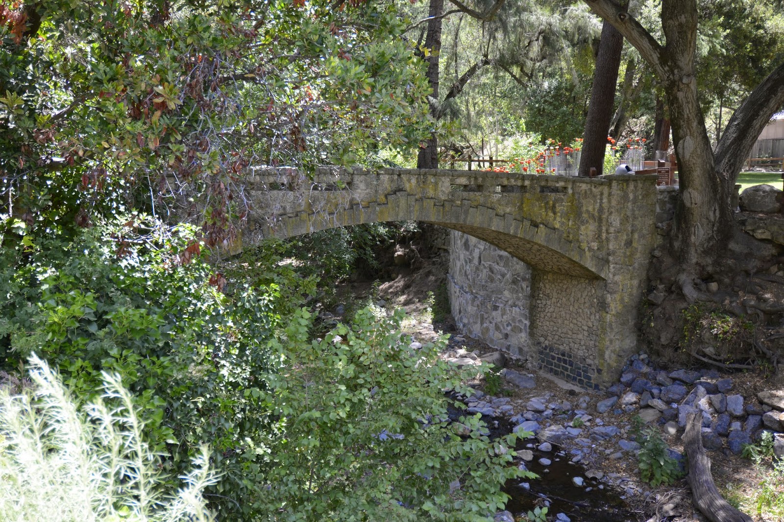
May 2014 (37.39452, -121.81178) Alum Rock Park Bridge
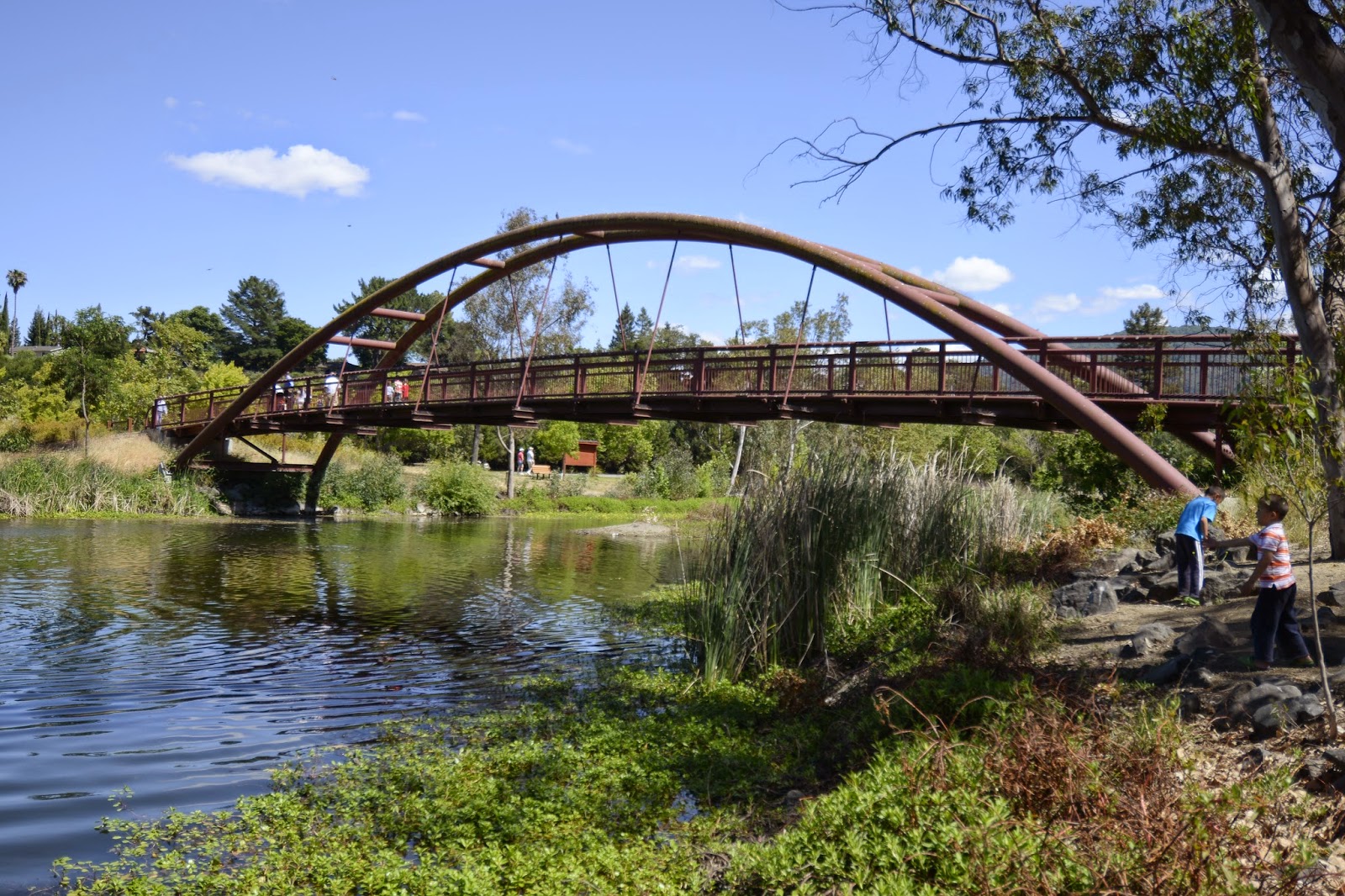
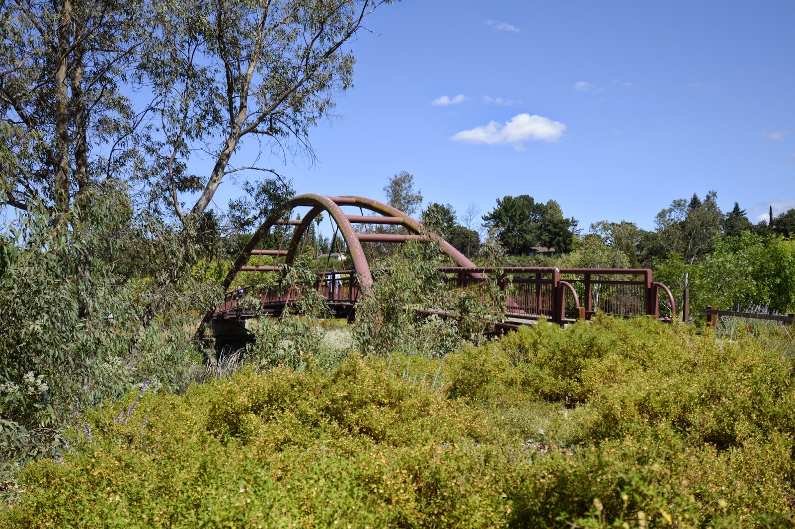
Some more photos of the Alum Rock Park Bridge. Alum Rock Park was the first municipal park in California (founded in 1872). The Alum Rock Park Bridge was built in 1913 as a tourist railroad bridge and designed by a famous bridge engineer, John B Leonard. From the early 1900s the park was a popular resort with a spa, swimming pool, mineral baths, and restaurant. Visitors rode the tourist train from San Jose into the park until the railroad closed in the 1920s.
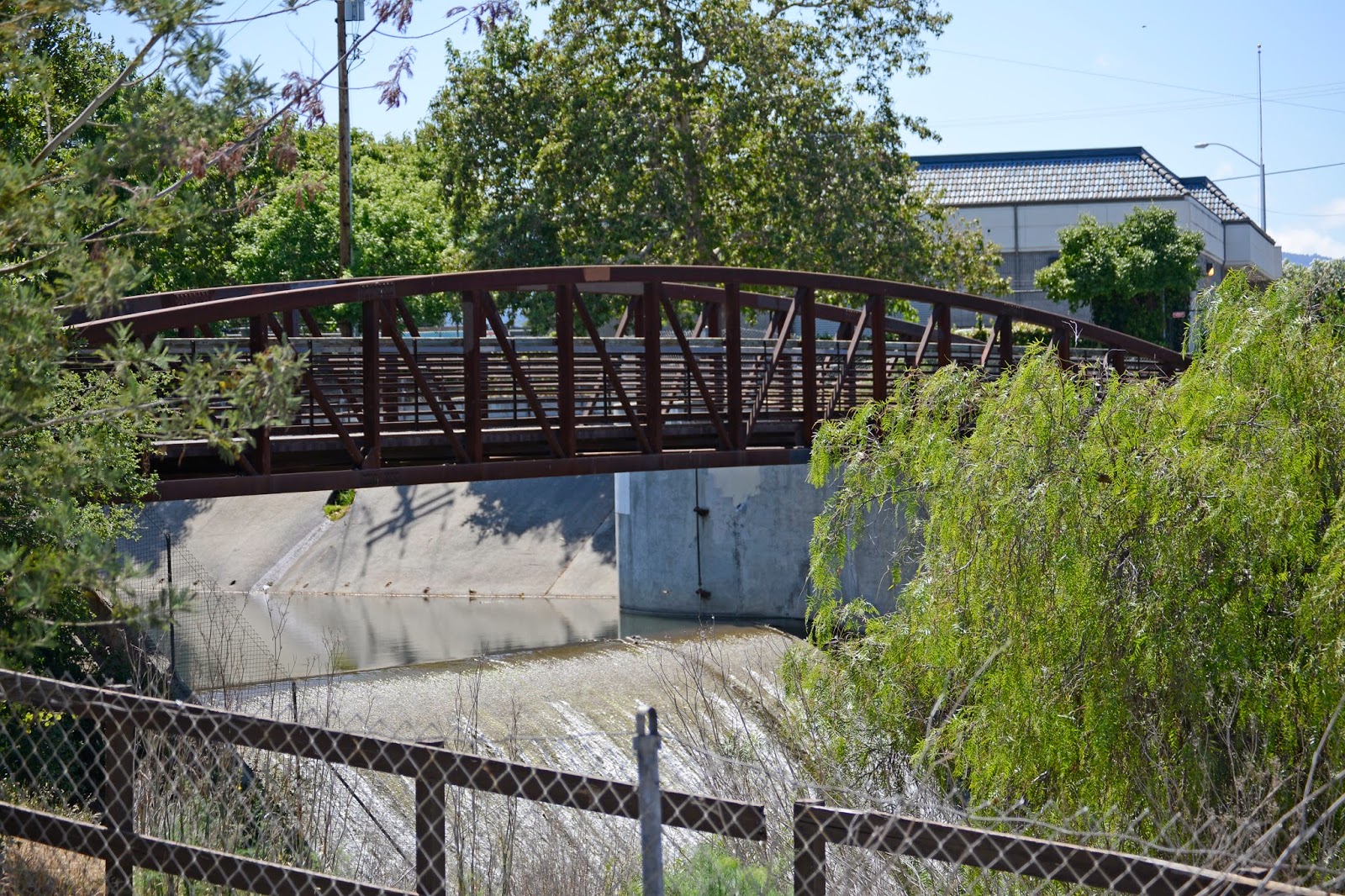
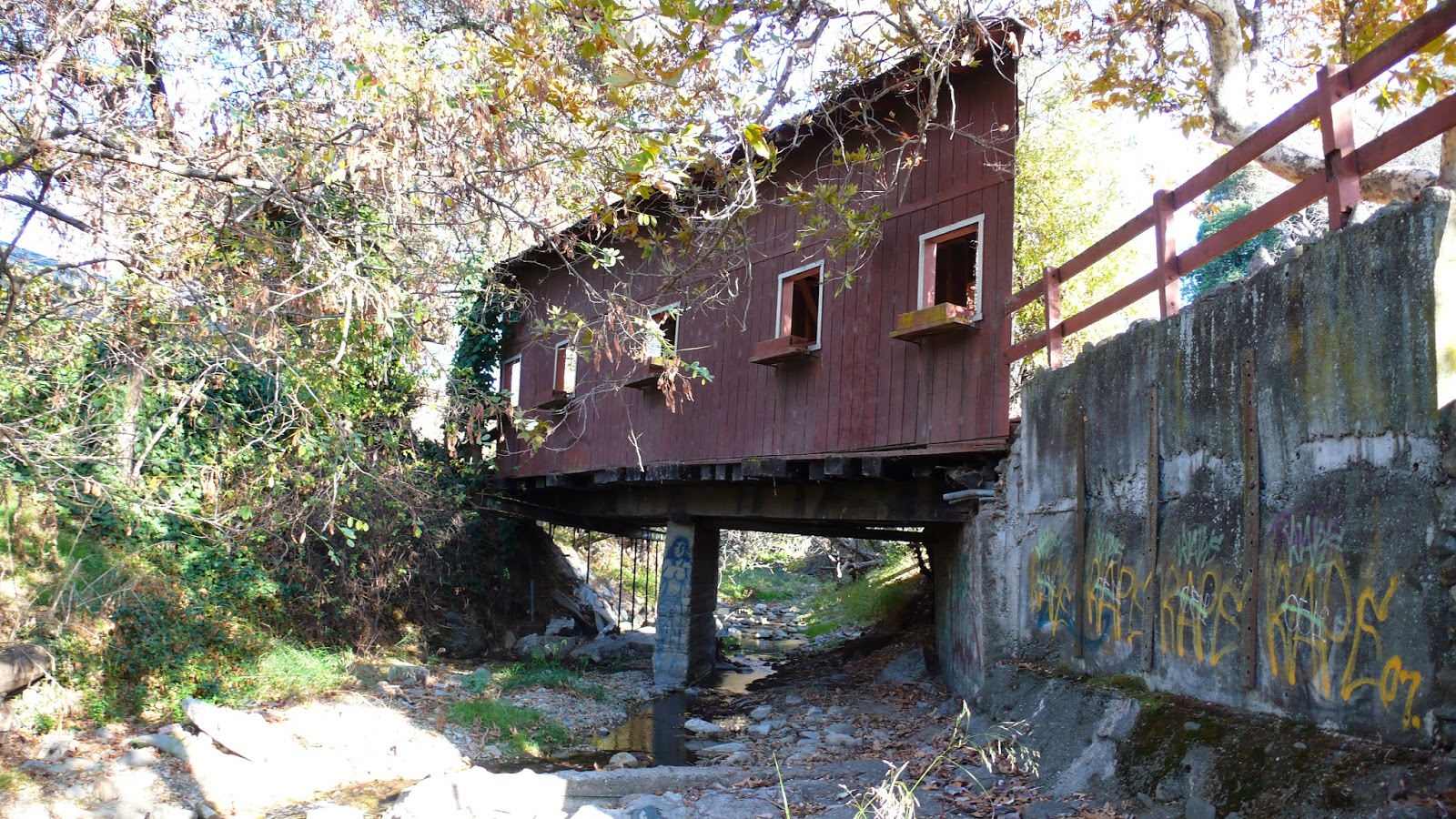
This bridge is 250 ft long with a 130 ft long arch span, making it one of the longest closed spandrel arch bridges in the state. The bridge includes haunched T girder end spans and an arch main span over the creek. The span on the west end has been filled in, perhaps because the road that once went under it has been closed (see photo below). 
Creative Commons License
Santa Clara County, California Bridges: Alum Rock Park Bridge (2) by Mark Yashinsky is licensed under a Creative Commons Attribution-NonCommercial-NoDerivatives 4.0 International License.

Monday, May 19, 2014

Santa Clara County, California Bridges: Alum Rock Park Bridge (1)

May 2014 (37.39452 Degrees-121.81178 Degrees) Alum Rock Park Bridge
Santa Clara County is interesting because of its diverse population. San Jose, Silicon Valley, and Stanford University all thrive within its borders. I recently returned to Santa Clara to photograph more interesting bridges. For some reason, most of these bridges are in parks. Does that mean that bridges are better preserved in parks than on highways? 
The first bridge I photographed was in Alum Rock Park, which had half a dozen nice bridges. Most of these are intricately-shaped stone arch bridges, but the Alum Rock Park Bridge is a concrete closed spandrel arch bridge with a stucco-like appearance. This bridge is so big, that I had trouble getting the whole structure into a single photo. The bridge has several parts including a long arch over Penitencia Creek and a 'T' girder span over Alum Rock Avenue. The arch has a large superelevation at one end that gives it a highly distorted appearance. We'll take another look at this interesting bridge tomorrow. 
Creative Commons License
Santa Clara County, California Bridges: Alum Rock Park Bridge (1) by Mark Yashinsky is licensed under a Creative Commons Attribution-NonCommercial-NoDerivatives 4.0 International License.

Sunday, May 18, 2014

Santa Clara County, California Bridges: Piedmont Road Bridges across Upper Penitencia Creek

October 2007 (37.39167 Degrees-121.84167 Degrees) Piedmont Road Bridges
The last bridges we looked at after the Alum Rock Earthquake were the Piedmont Road Bridges across Upper Penitencia Creek (37C0135L/R). These are modern (1975) three span slab bridges on reinforced concrete pier walls. We studied these bridges, but couldn't find any damage, and concluded that large 0.3 second accelerations are not indicative of bridge damage during earthquakes.
Creative Commons License
Santa Clara County, California Bridges: Piedmont Road Bridges across Upper Penitencia Creek by Mark Yashinsky is licensed under a Creative Commons Attribution-NonCommercial-NoDerivatives 4.0 International License.

Saturday, May 17, 2014

Santa Clara County, California Bridges: Penitencia Creek Bridges

October 2007 (37.39500 Degrees-121.82778 Degrees) Dorel Drive Bridge
At the intersection of Penitencia Creek Road and Dorel Drive are a couple of bridges. The Dorel Drive Bridge across Penitencia Creek (37C0753) is a single span concrete T girder bridge that was built in 1965 (see photo below).
The only unique aspects of this bridge are the stream gauge recording station and the graffiti on the abutments.
However, next to the county-owned bridge is a privately-owned covered bridge, which looks like an old building set on top of two abutments and a concrete pier wall. 
Among the unusual aspects of this bridge are the windows with flower boxes the very high skew, the many 'no trespassing' signs, and the fact that it's still standing.
Creative Commons License
Santa Clara County, California Bridges: Penitencia Creek Bridges by Mark Yashinsky is licensed under a Creative Commons Attribution-NonCommercial-NoDerivatives 4.0 International License.