Saturday, April 30, 2011

Australia's Bridges: Captain Cook Bridges across the Brisbane River in Queensland (2)

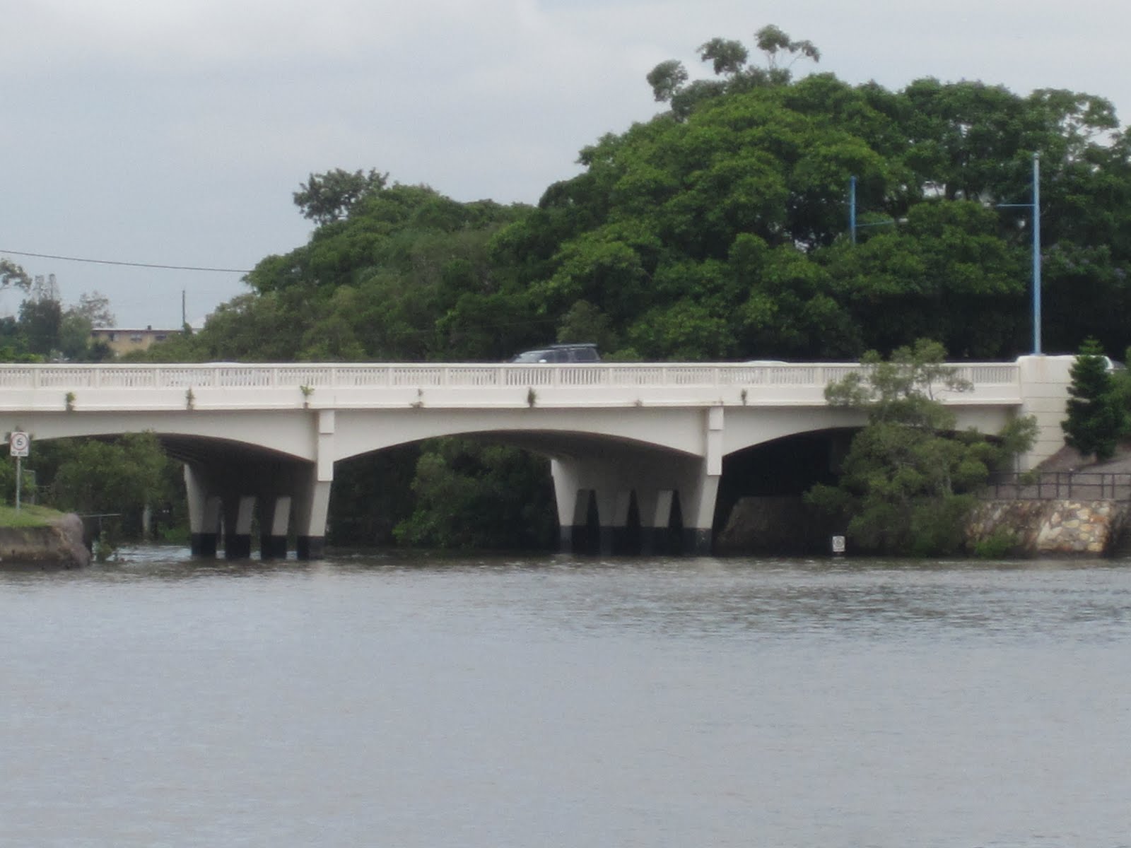
March 2011 (-27.481 deg., 153.029 deg.) Captain Cook Bridges

Another view of the Captain Cook Bridges. They have five continuous spans resting on squat trapezoidal piers. The longest span is 600 ft  and the bridges are 1821 ft long. They carry the most traffic across the Brisbane River, more than a million vehicles a week.  

The Brisbane River is about 200 miles long from it's source at Mt Stanley to its mouth in Moreton Bay. In this photo you can still see mangroves growing on the banks. There are bull sharks in the river and the tide can flow 60 miles upstream. Despite being dammed, the river flooded in January causing considerable damage. A big section of the Riverwalk broke free and threatened bridges downstream. Tugboat operators managed to get hold of it and guided it around bridge piers without it causing any damage.
Creative Commons License
Australia's Bridges: Captain Cook Bridges across the Brisbane River in Queensland (2) by Mark Yashinsky is licensed under a Creative Commons Attribution-NonCommercial-NoDerivs 3.0 Unported License.

Friday, April 29, 2011

Australia's Bridges: Captain Cook Bridges across the Brisbane River in Queensland (1)

March 2011 (-27.481 deg., 153.029 deg.) Captain Cook Bridges

After continuing upstream past the Story Bridge we reached the Captain Cook Bridges at the next bend in the river. Since James Cook was the first European to reach Australia's eastern coast (in 1770) he probably has a similar reputation in Australia as Christopher Columbus has in the United States.


These bridges were built in 1972. Their structure is similar to the Gateway Bridges, with haunched cast-in-place box girders: but lower, shorter, and narrower than those bridges. We'll take another look at the Captain Cook Bridges tomorrow.
Creative Commons License
Australia's Bridges: Captain Cook Bridges across the Brisbane River in Queensland (1) by Mark Yashinsky is licensed under a Creative Commons Attribution-NonCommercial-NoDerivs 3.0 Unported License.

Thursday, April 28, 2011

Australia's Bridges: Breakfast Creek Bridge in Queensland

March 2011 (-27.442 deg., 153.046 deg.) Breakfast Creek Bridge

I thought that this photo I took along the Brisbane River was of the Breakfast Creek Bridge but when I looked for it on the Internet, they showed a steel girder bridge from 1889. However after doing some more searching I found out that the steel bridge was removed in 1959, so I'm assuming that it was replaced with this three span concrete bridge.

Creative Commons License
Australia's Bridges: Breakfast Creek Bridge in Queensland by Mark Yashinsky is licensed under a Creative Commons Attribution-NonCommercial-NoDerivs 3.0 Unported License.

Wednesday, April 27, 2011

Australia's Bridges: Story Bridge across the Brisbane River in Queensland

March 2011 (-27.463 deg., 153.036 deg.) Story Bridge over the Brisbane River


After the ferry turned around at the Gateway Bridges, we travelled back upstream for about six miles to Central Brisbane and the Story Bridge.

Despite the floods, downtown Brisbane continues to grow. It's the third largest city in Australia and its also a very nice place to live or to visit. Just as the Harbour Bridge dominates the waterfront in Sydney, the Story Bridge seems equally prominent on Brisbane's waterfront. 

This bridge has a steel cantilever through truss, which used to be popular for spans of around 1000 ft (the Story Bridge has a 925 ft center span). We don't build this kind of bridge anymore in California but we still have plenty of them that need maintenance and repair. The reinforced concrete tower bases are nicely proportioned and painted white, which is a nice touch.


Construction on the bridge began in 1935 (during the Depression), it was completed in 1940, and helped ease congestion in Central Brisbane. The bridge (as is usually the case) was named after a politician who was instrumental in getting the project funded.
Creative Commons License
Australia's Bridges: Story Bridge across the Brisbane River in Queensland by Mark Yashinsky is licensed under a Creative Commons Attribution-NonCommercial-NoDerivs 3.0 Unported License.

Tuesday, April 26, 2011

Australia's Bridges: Sir Leo Hielschel (Gateway) Bridges across the Brisbane River in Queensland

March 2011 (-27.444 deg., 153.100 deg.) Gateway Bridges over the Brisbane River


After spending a week in Sydney we traveled north to Brisbane.

Last year, floods caused damage all along the Brisbane River, and the region was still undergoing repairs during our visit. We took the CityCat Ferry from the Riverside Ferry Terminal (one of the few terminals that remained undamaged). The ferry traveled downstream to the Gateway Bridges (the last bridges before the Pacific) before turning around and heading back to Brisbane.

The Gateway Bridges are two parallel cast-in-place box girder bridges with main spans of 850 ft. The first bridge was built in 1986 and was the record holder for the longest prestressed cantilever girder span (currently the Shibanpo in China) for many years. A second bridge was added in 2010.

The bridges are over a mile long and each bridge carries six lanes of traffic. The height was controlled by the nearby airport and by ship traffic to about 260 ft above sea level. The owners recently changed the name to the Leo Hielschel Bridges despite strong opposition.  They implemented electronic toll collection a few years ago, which helped reduced traffic accidents. They also added fences, which reduced the number of jumpers. 
Creative Commons License
Australia's Bridges: Sir Leo Hielschel (Gateway) Bridges across the Brisbane River in Queensland by Mark Yashinsky is licensed under a Creative Commons Attribution-NonCommercial-NoDerivs 3.0 Unported License.

Monday, April 25, 2011

Australia's Bridges: Footbridge over State Route 40 in Darling Harbour, Sydney (3)

March 2011 (-33.871 deg., 151.203 deg.) Footbridge in Darling Harbour

Footbridges (such as this futuristic fantasy) are needed when an expressway sits next to a promenade. Actually this bridge is more Rococo than Modern with flourishes that include a round mirror embedded in the parabolic brace and a glass diamond atop the roof on the far side. The message is more about jewelry (or submarines) than about architecture or bridges. 


You can barely see the diagonal pier supporting the bridge because of all the shrubbery, which may have been its purpose. The parabolic brace houses an escalator to carry people across the expressway.
Creative Commons License
Australia's Bridges: Footbridge over State Route 40 in Darling Harbour, Sydney (3) by Mark Yashinsky is licensed under a Creative Commons Attribution-NonCommercial-NoDerivs 3.0 Unported License.

Sunday, April 24, 2011

Australia's Bridges: Footbridge over State Route 40 in Darling Harbour, Sydney (2)

March 2011 (-33.871 deg., 151.203 deg.) Footbridge in Darling Harbour

A view from slightly below the deck of this cable-stayed bridge. It looks like not an ounce of material was wasted. Each cable is threaded through the top of the tower and anchored to a tubular floor beam at each end. The tower leg elements have just enough bracing to prevent buckling. The channels along the deck look just deep enough for the dead and live load. 

The tower is located slightly off-center to allow pedestrians to enter a monorail platform alongside of the bridge. The platform legs are between several connectors for State Route 40 below. It all looks a little crowded but it works.
Creative Commons License
Australia's Bridges: Footbridge over State Route 40 in Darling Harbour, Sydney (1) by Mark Yashinsky is licensed under a Creative Commons Attribution-NonCommercial-NoDerivs 3.0 Unported License.

Saturday, April 23, 2011

Australia's Bridges: Footbridge over State Route 40 in Darling Harbour, Sydney (1)

March 2011 (-33.871 deg., 151.203 deg.) Footbridge in Darling Harbour


Walking east on the Pyrmont Bridge you have to climb some stairs and walk across a cable-stayed footbridge to avoid being set down at a busy intersection. The footbridge over S.R. 40 is a 240 ft long, two-span steel bridge with four cables in a fan-arrangement descending from each tower leg. The bridge looks slightly out of place next to the ornate Pyrmont Bridge but reflects the eclectic nature of Sydney. We'll take another look at this bridge tomorrow.
Creative Commons License
Australia's Bridges: Footbridge over State Route 40 in Darling Harbour, Sydney (1) by Mark Yashinsky is licensed under a Creative Commons Attribution-NonCommercial-NoDerivs 3.0 Unported License.

Friday, April 22, 2011

Australia's Bridges: Glebe Viaducts in NSW (2)

March 2011 (-33.875 deg., 151.177 deg.) Glebe Viaducts


This photo of the Glebe Viaduct in Jubilee Park was taken half a mile away from the ANZAC (Cable-Stayed) Bridge.  Consequently, we don't see much of this bridge, which is the longest masonry viaduct in New South Wales.


According to the Heritage Branch Website, "The bricks are laid in English bond pattern with soldier courses defining the archways. The arches are evenly spaced, being 28 x 10.06m (33 feet) clear spans. The viaduct stretches approximately 446.5 metres, making it the largest brick viaduct in the NSW rail system."


I imagine the bricks came from the Brick Pit by Olympic Park that we visited on March 27th and 28th. A few years ago the viaducts were modified with catenary poles and an overhead power line to carry the Metro Light Rail. 


On our last night in Australia, we walked to Glebe for dinner just as it started to rain. However, when we asked where the closest train station was to get back to Sydney, we were told it was Central Station!
Creative Commons License
Australia's Bridges: Glebe Viaducts in NSW (2) by Mark Yashinsky is licensed under a Creative Commons Attribution-NonCommercial-NoDerivs 3.0 Unported License.

Thursday, April 21, 2011

Australia's Bridges: Glebe Viaducts in NSW (1)


March 2011 (-33.875 deg., 151.192 deg.) Glebe Viaducts

In 1892 Sydney's Metropolitan Railway began building a separate freight line from Central Station and Darling Harbour out to Rozelle Bay and Glebe. One of the nice features of this line are the viaducts at Wentworth Park (shown) and Jubilee Park. Each viaduct included millions of bricks and thousands of timber piles over what was originally a swamp.

More information about the Glebe Viaducts is available at the Heritage Branch Website. We'll look at the Jubilee Park Viaduct tomorrow. 
Creative Commons License
Australia's Bridges: Glebe Viaducts in NSW (1) by Mark Yashinsky is licensed under a Creative Commons Attribution-NonCommercial-NoDerivs 3.0 Unported License.

Wednesday, April 20, 2011

Australia's Bridges: Railway Square Underbridge at Sydney's Central Station (2)

March 2011 (-33.882 deg., 151.206 deg.) Railway Square Underbridge

A closer look at the Railway Square Underbridge. We are now looking to the southwest and so we can see Central Station (and some new construction) in the background. You can also see that traffic goes on the left side of the street in Australia (also in Great Britain, Japan, New Zealand, etc.).

The bridge has three main spans for cars and two tiny spans for foot traffic. It's hard to imagine when the bridge was first built and carriages rode under the arches. The vaulted soffits under the bridge look like true arches rather than the haunched slabs on the Eddy Avenue Underbridge. The one on the far left is covered with stone but the others look to be concrete. The bridge looks like it was recently restored so perhaps the stones on the soffit were removed (or they're being replaced?).
Creative Commons License
Australia's Bridges: Railway Square Underbridge at Sydney's Central Station (2) by Mark Yashinsky is licensed under a Creative Commons Attribution-NonCommercial-NoDerivs 3.0 Unported License.

Tuesday, April 19, 2011

Australia's Bridges: Railway Square Underbridge at Sydney's Central Station (1)

March 2011 (-33.882 deg., 151.206 deg.) Railway Square Underbridge

At the other end of the station (across Eddy Avenue) is an old stone masonry bridge (1856). According to the Heritage Council Website"The overbridge at Railway Square .... opened the same day as the main railway in 1855 and is the oldest piece of railway infrastructure remaining in NSW and the only known feature built by the original Sydney Railway Company." 

Central Station has several levels for different modes of transportation. The Railway Square Underbridge provides trams and buses access to the station and is the oldest railway bridge in Australia that's still in use. We'll take a closer look at this bridge tomorrow.

Creative Commons License
Australia's Bridges: Railway Square Underbridge at Sydney's Central Station (1) by Mark Yashinsky is licensed under a Creative Commons Attribution-NonCommercial-NoDerivs 3.0 Unported License.

Monday, April 18, 2011

Australia's Bridges: Eddy Avenue Underbridge at Sydney's Central Station

March 2011 (-33.883 deg., 151.208 deg.) Eddy Avenue Underbridge


I'm standing on Eddy Avenue looking east at the Eddy Avenue Underbridge (1923) that carries trains in and out of Sydney's Central Station. An underbridge is a British term for a bridge that allows traffic to travel below it. Not surprisingly, the bridge and road are named after railway commissioner Edward Miller Gard Eddy (1851-1897). There's a lot of additional information on Sydney's Central Station and it's bridges on the Heritage Council website

Note the use of sandstone as a facing material on this reinforced concrete bridge. In Sydney the use of sandstone as a facing material (rather than solid sandstone) may indicate a structure is of less significant but it also indicates a change in technology as reinforced concrete became more important. The sandstone on this bridge appears to have become discolored, especially on the railing. I believe some of the sandstone on the station was recently replaced due to similar problems. 

The bridge is very wide to carry trains from the eight railway platforms that are located just south of the bridge. All of the trains on these platforms are electric as indicated by the overhead line on the bridge. Much of the infrastructure at Central Station had to be modified as trains went from being powered by steam, to electricity, to diesel fuel during the last century.

The bridge is actually a reinforced concrete pierwall and slab structure that was artfully disguised to look like a stone masonry arch structure. This artifice was used to match the station's architecture while taking advantage of the better performance of reinforced concrete. 
Creative Commons License
Australia's Bridges: Eddy Avenue Underbridge at Sydney's Central Station by Mark Yashinsky is licensed under a Creative Commons Attribution-NonCommercial-NoDerivs 3.0 Unported License.

Sunday, April 17, 2011

Australia's Bridges: Eddy Avenue Steel Tram Underbridge in Sydney

March 2011 (-33.882 deg., 151.208 deg.) Eddy Avenue Steel Tram Underbridge

Another photo of the 1923 Eddy Avenue Steel Tram Underbridge. I'm standing in Belmore Park looking toward the northwest corner of Central Station. There's another bridge on the northeast corner that drops people off at the station. 

This bridge has nice architectural details such as the concrete pylons, the slope paving along the embankment, the sandstone-faced piers, the elegant balustrade, etc., which identify the adjacent train station as an important civic structure.
Creative Commons License
Australia's Bridges: Eddy Avenue Steel Tram Underbridge in Sydney by Mark Yashinsky is licensed under a Creative Commons Attribution-NonCommercial-NoDerivs 3.0 Unported License.

Saturday, April 16, 2011

Australia's Bridges: Eddy Avenue Bridges at Sydney Central Station

March 2011 (-33.882 deg., 151.208 deg.) Eddy Avenue Bridges

During my visit, I stayed near Sydney's Central Station, which is the oldest and largest train station in Australia. Most intercity, suburban, and urban travel terminates here and it's built of the same red sandstone as most of the older bridges around Sydney.

The front of the station is on Eddy Avenue. There's a riveted-steel plate girder bridge on stone piers. Behind it is a wide, three span, reinforced concrete railway bridge with the soffit curved to simulate arches and faced with sandstone (it is continuation of the bridge over Hay Street that was shown on March 9, 2011). There are three spans of 45.5 feet. It was designed by the engineering staff of the New South Wales Government Railway (NSWGR) and built by the Metropolitan Railway Construction Branch in 1923.
Creative Commons License
Australia's Bridges: Eddy Avenue Bridges at Sydney Central Station by Mark Yashinsky is licensed under a Creative Commons Attribution-NonCommercial-NoDerivs 3.0 Unported License.

Friday, April 15, 2011

Australia's Bridges: Sydney Harbour Bridge (and Sydney Opera House)

March 2011 (-33.852 deg., 151.211 deg.) Sydney Harbour Bridge

Taking the ferry back into Sydney provides a nice view of the Sydney Opera House under the Harbour Bridge. The Opera House was designed by Danish architect Jorn Utzon (the construction engineer was Ove Arup). There were many problems during construction and Utzon eventually resigned as head architect. 


The Tall Bridge Guy mentioned the value of having a famous engineer or architect design your iconic structure. One value of being famous is that you can more easily handle whatever problems occur. I don't think that Frank Gehry and Santiago Calatrava would get bent out of shape by cost overruns or construction problems. The owner hires competent professionals to ensure their vision is executed. Utzon's reputation was damaged by all the problems that occurred and he never designed another iconic structure.
Creative Commons License
Australia's Bridges: Sydney Harbour Bridge (and Sydney Opera House) by Mark Yashinsky is licensed under a Creative Commons Attribution-NonCommercial-NoDerivs 3.0 Unported License.

Thursday, April 14, 2011

Australia's Bridges: Blue Mountains Footbridge in NSW

March 2011 (-33.735 deg., 151.315 deg.) Blue Mountains Footbridge

The quickest way to get to the 'Outback' from Sydney is to take the train into the Blue Mountains, a three hour journey. Once there, you can spend the day hiking through Eastern Australia's layer cake geology, thorny succulents, and some flimsy-looking bridges.
Creative Commons License
Australia's Bridges: Blue Mountains Footbridge in NSW by Mark Yashinsky is licensed under a Creative Commons Attribution-NonCommercial-NoDerivs 3.0 Unported License.

Wednesday, April 13, 2011

Australia's Bridges: Elizabeth Street Footbridge across the Parramatta River in NSW

March 2011 (-33.813 deg., 151.009 deg.) Elizabeth Street Footbridge


This isn't the end of the Parramatta River, but it is the end of the ferry ride.  A weir blocked our progress and so I took the ferry back to Sydney, and missed five or six interesting bridges further upstream.

In the foreground is the Elizabeth Street Footbridge with its decorated canopy. Behind it, on Y-shaped piers, is the Barry Wilde Bridge. Barely visible in the distance is the Lennox Bridge, a stone arch and one of the oldest bridges in Australia (1839).
Creative Commons License
Australia's Bridges: Elizabeth Street Bridge across the Parramatta River in NSW by Mark Yashinsky is licensed under a Creative Commons Attribution-NonCommercial-NoDerivs 3.0 Unported License.

Tuesday, April 12, 2011

Australia's Bridges: MacArthur Street (Gasworks) Bridge across the Parramatta River in NSW

March 2011 (-33.815 deg., 151.012 deg.) MacArthur Street Bridge

The first Europeans didn't arrive in Australia until the end of the 18th century. One hundred years later (in 1901) Australia became a Commonwealth and eventually one of the world's most prosperous nations. Bridges built during the colonial period are of particular interest since the population was so dependent on it's own resources.

 The MacArthur Street (Gasworks) Bridge is an old (1885) iron lattice truss on handsome sandstone piers. It has three (31 m long) truss spans as well as steel girder approach spans for a total length of 110 m. It has two narrow lanes and a walkway (apparently a common feature) supported on the west side.

There is quite a bit of additional information on this bridge at the Heritage Website.  
Creative Commons License
Australia's Bridges: MacArthur Street (Gasworks) Bridge across the Parramatta River in NSW by Mark Yashinsky is licensed under a Creative Commons Attribution-NonCommercial-NoDerivs 3.0 Unported License.

Monday, April 11, 2011

Australia's Bridges: James Ruse Drive Bridge across the Parramatta River in NSW

March 2011 (-33.814 deg., 151.023 deg.) James Ruse Drive Bridge

About a thousand feet upstream from the two Camellia Bridges is the James Ruse Drive Bridge, which was completed in 1966. It's a four span precast girder bridge on four column bents. 

James Ruse Drive is a six lane road with a lot of truck traffic across the Parramatta River. The river is becoming quite narrow and the piers are protected with timber fenders.
Creative Commons License
Australia's Bridges: John Ruse Drive Bridge across the Parramatta River in NSW by Mark Yashinsky is licensed under a Creative Commons Attribution-NonCommercial-NoDerivs 3.0 Unported License.

Sunday, April 10, 2011

Australia's Bridges: Camellia Bridges across the Parramatta River in NSW

March 2011 (-33.815 deg., 151.026 deg.) Camellia Bridges

Alan commented in yesterday's blog that the superstructure of the Camellia Utility Bridge may originally have been on the Camellia Railway Bridge. The evidence suggests that he's right. We can see in the photo above that the piers of the two bridges are equally spaced, making the placement of the three spans onto the steel column caps of the utility bridge fairly straightforward.


I mentioned in a previous blog several reasons why we often see new and old bridges side by side. Alan brought up the additional point that a parallel bridge can be used as a detour during construction and that moving the superstructure onto an adjacent structure allows trains to cross the river while the new bridge is being built. 


It is likely that the three trusses on the utility bridge were originally on the railway bridge. We can see how the railway bridge is narrow at the two ends. This matches the width of the trusses. The Heritage Council article mentioned that the original railway bridge had a wrought iron latticed truss. However, I think that may have been from an even earlier era (when the masonry abutments were first built). The laced and riveted Warren trusses must have replaced the wrought iron trusses when a stronger bridge was required. It's a little odd that there is no deck on the utility bridge, but perhaps it was removed as needless weight when they moved the trusses to their new location.


The new railway bridge is also an interesting structure. For one thing it is very wide for a single set of tracks. Perhaps they planned to widen the ends and add another track in the future? More likely the old abutments are considered of historic value and so they may not be allowed to widen the ends of the bridge. Also, it is a little unusual to build a truss bridge when box girders can provide longer spans at less cost. It's even more unusual to build a pony truss without any lateral support from cross-braces. It's also unusual to build a continuous three span truss that is over three hundred feet long. Was it shipped on a barge or somehow fabricated on the site? The steel pier legs that descend from the truss make it a much stiffer, almost rigid structure. Also, it looks like a very lightweight walkway is attached to the west side of the railway bridge.
Creative Commons License
Australia's Bridges: Camellia Bridges across the Parramatta River in NSW by Mark Yashinsky is licensed under a Creative Commons Attribution-NonCommercial-NoDerivs 3.0 Unported License.

Saturday, April 9, 2011

Australia's Bridges: Camellia Utility Bridge across the Parramatta River in NSW

March 2011 (-33.815 deg., 151.026 deg.) Camellia Utility Bridge


Next to the Camellia Railway Bridge is another utility bridge with two waterlines across the Parramatta River. It looks like there's room for a third pipeline, maybe in the future. The bridge doesn't have a deck, just some floor beams to support the pipes. It's a three span through truss bridge (about 400 ft long) with interesting two column bents that includes infill walls with two oval holes. 

We are all standing on the deck of the RiverCat ferry enjoying the river, which has become quite narrow as we continue upstream. Its a pretty river, which used to be quite polluted until an effort was made to stop industry from pouring waste into it.
Creative Commons License
Australia's Bridges: Camellia Utility Bridge across the Parramatta River in NSW by Mark Yashinsky is licensed under a Creative Commons Attribution-NonCommercial-NoDerivs 3.0 Unported License.

Friday, April 8, 2011

Australia's Bridges: Camellia Railway Bridge across the Parramatta River in NSW

March 2011 (-33.815 deg., 151.026 deg.) Camellia Railway Bridge

The Camellia Railway Bridge has steel legs that wrap around concrete columns to support the long center span of this through truss structure. It's also a very modern truss, having been completed in 1995 making it the newest of the Parramatta River crossings. However, according to the Heritage Council the masonry abutments are unaltered from a 19th century bridge and provide details on early bridge construction in Australia.

Creative Commons License
Australia's Bridges: Camellia Railway Bridge across the Parramatta River in NSW by Mark Yashinsky is licensed under a Creative Commons Attribution-NonCommercial-NoDerivs 3.0 Unported License.

Thursday, April 7, 2011

Australia's Bridges: Rydalmere Pedestrian Bridge across the Parramatta River in NSW

March 2011 (-33.818 deg., 151.041 deg.) Rosehill/Rydalmere Footbridge


A kilometer upstream from the Silverwater Bridge is the Rydalmere Pedestrian Bridge.  It's a nice looking two span, through truss bridge on two column bents with a pedestrian walkway between two waterlines. There is also a steep ramp on each side of the bridge to carry water and pedestrians up onto the middle two spans.


The bridge has a rather flimsy looking fender system around the bent in the river. I guess it's a good thing that big vessels don't travel on the Parramatta River anymore.  I have a special fondness for utility bridges and this is a well designed and well constructed structure. I think I'd like to write a book on utility bridges one day.
Creative Commons License
Australia's Bridges: Rydalmere Pedestrian Bridge across the Parramatta River in NSW by Mark Yashinsky is licensed under a Creative Commons Attribution-NonCommercial-NoDerivs 3.0 Unported License.

Wednesday, April 6, 2011

Australia's Bridges: Silverwater Bridge across the Parramatta River in NSW

March 2011 (-33.824 deg., 151.051 deg.) Silverwater Bridge


The ferry went another two miles upstream before reaching the next Parramatta River Crossing.


The Silverwater Bridge has a six span superstructure with four continuous, haunched concrete box girders on double pier wall bents. The bridge was completed in 1962 and carries Route 6 between the towns of Silverwater and Ermington over the Parramatta River.


I couldn't find much else about this bridge (who built it, how it was built, etc.). If anyone has more information about this handsome river crossing, please let us know.
Creative Commons License
Australia's Bridges: Silverwater Bridge over the Parramatta River in NSW by Mark Yashinsky is licensed under a Creative Commons Attribution-NonCommercial-NoDerivs 3.0 Unported License.