Tuesday, April 30, 2013

Amador County, California Bridges: Camanche Road Bridge across Jackson Creek

February 2013 (38.29056 Degrees, -120.92778 Degrees) Camanche Road Bridge
The Camanche Road Bridge (26C0012) crosses Jackson Creek about a mile west of yesterday's bridge. It is a four span continuous cast-in-place reinforced concrete slab bridge built in 1976. The slab is supported on hexagonal pile extensions with drop bent caps and on end-diaphragm abutments. The bridge is 87 ft long, 28 ft wide, and with a 10 degree skew. It carries about 1800 vehicles a day and has a sufficiency rating of 81. The creek looks wider here but the banks are beginning to slump and there is some concern of scour around the piles during spring floods.
At work, we are trying to develop details to use more ductile pile extensions to support slab bridges for earthquakes. However, the standard slab details don't have enough reinforcement to force plastic hinging in the pile extensions.
Creative Commons License
Amador County, California Bridges: Camanche Road Bridge across Jackson Creek by Mark Yashinsky is licensed under a Creative Commons Attribution-NonCommercial-ShareAlike 3.0 United States License.

Monday, April 29, 2013

Amador County, California Bridges: Buena Vista Road Bridge across Jackson Creek

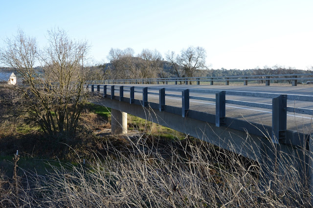
February 2013 (38.28861, -120.91361) Jackson Creek Bridge
Jackson Creek flows southwest of Jackson where it is dammed to form Lake Amador and then dammed a couple more times before flowing into Dry Creek southwest of Ione.

The Jackson Creek Bridge (26C0047) carries Buena Vista Road over Jackson Creek south of Ione. It's a cast in place, prestressed concrete box girder bridge on a single column bent and seat-type abutments. The bridge has two 118 ft long spans, a 32.8 ft wide deck, and it's on a 30 degree skew. It was built in 1994, it carries about 1850 vehicles a day, and has a sufficiency rating of 96.

This type of bridge is preferred by contractors in California. They have plenty of forms and falsework, and can build this type of bridge cheaply with a minimum of labor. However, the federal government is pushing California to do more accelerated bridge construction using precast bridge elements.

I took the photo (above) in the winter but when I came back in the spring the bridge was surrounded by foliage including lots of poison oak!
Creative Commons License
Amador County, California Bridges: Buena Vista Road Bridge across Jackson Creek by Mark Yashinsky is licensed under a Creative Commons Attribution-NonCommercial-ShareAlike 3.0 United States License.

Sunday, April 28, 2013

Amador County, California Bridges: East Ione Underpass over SR 88

March 2013 (38.33366 Degrees, -120.89856 Degrees) East Ione Underpass
I couldn't find too many railroad bridges in Amador County. There were mostly at-grade crossings, usually without gates and I never saw a train.

The East Ione Underpass (26 0004) is a 95 ft long through steel girder railroad bridge on two column bents and with timber and steel trestle approaches. The bridge was built in 1958 and it's in good shape. It crosses State Route 88 a little southeast of Ione near mines and quarries that include railroad sidings.
Creative Commons License
Amador County, California Bridges: East Ione Underpass over SR 88 by Mark Yashinsky is licensed under a Creative Commons Attribution-NonCommercial-ShareAlike 3.0 United States License.

Saturday, April 27, 2013

Amador County, California Bridges: Bridges across the South Fork of Jackson Creek

April 2013, South Fork Jackson Creek Bridges
The City of Jackson has many bridges because Jackson Creek and all of its tributaries go through town.  All the bridges that face State Route 49/88 have that creepy-looking stone facade on the barrier.
Because Jackson was settled during the Gold Rush, many of these bridges are old. For instance, the South Fork Jackson Creek Bridge (26C0004) shown below was built in 1925. It's a 8.7 meter long single span steel girder bridge carrying South Avenue.
Continuing upstream, the next South Fork Jackson Creek Bridge (26C0035) shown below was built in 1949. It's an 8.9 meter long single span steel girder bridge that carries French Bar Road and was built in 1949.
Further upstream, the next South Fork Jackson Creek Bridge (26C0049) is a three span continuous concrete slab that carries Mission Blvd and was built in 2005.
Creative Commons License
Amador County, California Bridges: Bridges across the South Fork of Jackson Creek by Mark Yashinsky is licensed under a Creative Commons Attribution-NonCommercial-ShareAlike 3.0 United States License.

Friday, April 26, 2013

Amador County, California Bridges: State Route 88 Bridge across the Middle Fork of Jackson Creek

March 2013 (38.35000°, -120.77028°) State Route 88 Bridge
Next to yesterday's Pitt Street Bridge is the State Route 88 Bridge across the Middle Fork of Jackson Creek. It's supposed to be a 5 span continuous concrete slab bridge, so I assume the first and last spans are hidden by curtain walls. The bridge is supported on pier walls that are preferred over fast moving streams (earthquake engineers don't like pier walls because they are shear-critical in the strong direction). The bridge is also on a high skew (earthquake engineers also don't like high skews) and it was built in 1948.

The Highway 88 Bridge is 122 ft long with a 36 ft long main span over the creek.  It carries about 10,000 vehicles a day and has a sufficiency rating of 73. Caltrans and the FHWA recently went through a major exercise to determine scour critical bridges in California and this bridge was determined to be okay.
Creative Commons License
Amador County, California Bridges: State Route 88 Bridge across the Middle Fork of Jackson Creek by Mark Yashinsky is licensed under a Creative Commons Attribution-NonCommercial-ShareAlike 3.0 United States License.

Thursday, April 25, 2013

Amador County, California Bridges: Pitt Street Bridge across the Middle Fork of Jackson Creek


March 2013 (38.35000°, -120.77083°) Pitt Street Bridge
At the intersection of State Routes 49 and 88 is the county seat of Jackson. The most important historic bridge in town is the Pitt Street Bridge over the Middle Fork of Jackson Creek. This 46 ft long bridge is a half-hipped Pratt pony truss built in 1902. It has a timber deck with a single traffic lane and a sidewalk cantilevering from the side of the truss.
The bottom chord is a tiny tension member that appears to be bowed downward from the weight of the floor beams. The bridge has sufficiency rating of 22.8 out of 100 and carries 500 vehicles a day. It's a 111 year old bridge that's eligible for (but has never been added to) the National Register of Historic Places.
Creative Commons License
Amador County, California Bridges: Pitt Street Bridge across the Middle Fork of Jackson Creek by Mark Yashinsky is licensed under a Creative Commons Attribution-NonCommercial-ShareAlike 3.0 United States License.

Wednesday, April 24, 2013

Amador County, California Bridges: State Route 104 Bridge across Sutter Creek

March 2013 (38.35500 Degrees, -120.93333 Degrees) Sutter Creek Bridge
As I've previously mentioned, Amador County is bordered by rivers and filled with creeks. We followed Sutter Creek to the west and it eventually flowed through the town of Ione. At Preston Avenue (SR104) on the east side of town is a three span continuous concrete slab bridge that crosses Sutter Creek on skinny pier walls. The bridge is 92 ft long, 52 ft wide, and was built in 1970. It carries 5100 vehicles a day and is in 'Good' condition with a sufficiency rating of 87.3.

Perhaps in acknowledgment to Ione's history as a gold mining town they've put stone facing stones on the concrete barriers (and an unattractive tall fence above the barrier).
Just west of the bridge is another one of those pony truss pedestrian bridges, which are apparently quite common, at least across Sutter Creek.
Creative Commons License
Amador County, California Bridges: State Route 104 Bridge across Sutter Creek by Mark Yashinsky is licensed under a Creative Commons Attribution-NonCommercial-ShareAlike 3.0 United States License.

Tuesday, April 23, 2013

Amador County, California Bridges: Sutter Creek Road Bridge across Sutter Creek

March 2013 (38.39889 Degrees, -120.77722 Degrees) Sutter Creek Road Bridge
Continuing east of the town of Sutter Creek on Sutter Creek Volcano Road we came to an old steel stringer bridge. This Sutter Creek Road Bridge (26C0041) was built in 1925 and widened in 1955. It's a continuous steel girder bridge composed of three 20 ft long spans on pier walls. It carries about 1450 vehicles a day and has a sufficiency rating of 61.3. Although the bridge is almost 90 years old, it is apparently ineligible for the National Register of Historic Places.
Creative Commons License
Amador County, California Bridges: Sutter Creek Road Bridge across Sutter Creek by Mark Yashinsky is licensed under a Creative Commons Attribution-NonCommercial-ShareAlike 3.0 United States License.

Monday, April 22, 2013

Amador County, California Bridges: Anne's Bridge across Sutter Creek

March 2013 (38.39299 Degrees, -120.80045 Degrees) Sutter Creek Footbridge
We avoided the State Route 49 Cutoff and took Old California 49 into the tourist town of Sutter Creek. Just east of town are a couple of tubular steel pedestrian bridges over Sutter Creek. They are Pratt pony truss bridges that use the railing as structural members to support the bridge. The bridge in today's blog has a plaque dedicated to Anne Conrardy, which suggests this bridge was at least partially constructed with funds from Anne's family.
Anne's bridge has a high camber, so it must be supported on strong foundations to resist the longitudinal force of the bowed superstructure. It has a grated steel deck to allow for drainage. The steel looks brown and is probably a type of Corten (weathering) steel.

These bridges look like they would be easy to fabricate in a factory or at the bridge site. A crane could pick up the bridge and set it on a pair of well supported abutments.
Creative Commons License
Amador County, California Bridges: Anne's Bridge across Sutter Creek by Mark Yashinsky is licensed under a Creative Commons Attribution-NonCommercial-ShareAlike 3.0 United States License.

Sunday, April 21, 2013

Amador County, California Bridges: State Route 49 Bridge across Rancheria Creek

March 2013 (38.42500, -120.84500) Rancheria Creek Bridge
Back at the Golden Chain Highway (SR49) just south of Drytown is a three span, prestressed concrete, continuous cast-in-place box girder bridge over Rancheria Creek. The bridge is just north of the State Route 49 Cutoff built in 2007 that we visited last month, which included the very tall Sutter Creek and Amador Creek Bridges.

The Rancheria Creek Bridge (26 0017) was built by Caltrans in 1983. It has a streamlined style, but I think what makes it attractive is its setting in a beautiful green, hilly landscape completely devoid of any sign of human existence.
The bridge is 330 ft long with a 120 ft long main span and 43.6 ft wide deck. It carries about 7600 vehicles a day and has a sufficiency rating of 97.6 out of 100.
Creative Commons License
Amador County, California Bridges: State Route 49 Bridge across Rancheria Creek by Mark Yashinsky is licensed under a Creative Commons Attribution-NonCommercial-ShareAlike 3.0 United States License.

Saturday, April 20, 2013

Amador County, California Bridges: State Route 26 Bridge across the N. Fk of the Mokelumne River (2)

April 2013 (38.42292 Degrees, -120.54128 Degrees) State Route 26 Bridge

Another view of the State Route 26 Bridge across the North Fork of the Mokelumne River. In the photo we can see that the center span is a T girder and the approach spans are slabs. It looks like they barely kept the two column bents out of the swiftly flowing river. Short walls between the columns guide the flow away from the piers.

I obtained the plans for this bridge, but they were hard to read. I had to invert white to black in Photoshop in order to see the drawing, which looks just like the photo.
Creative Commons License
Amador County, California Bridges: State Route 26 Bridge across the N. Fk of the Mokelumne River (2) by Mark Yashinsky is licensed under a Creative Commons Attribution-NonCommercial-ShareAlike 3.0 United States License.

Friday, April 19, 2013

Amador County, California Bridges: State Route 26 Bridge across the N. Fk of the Mokelumne River (1)

April 2013 (38.42292 Degrees, -120.54128 Degrees) State Route 26 Bridge
A little east of yesterday's Ponderosa Way Bridge the Mokelumne River splits into a North, Middle, and South Fork. All three rivers are crossed by State Route 26 with similar types of bridges.
The State Route 26 Bridge (30 0049) across the North Fork of the Mokelumne River is 204 ft long cast-in-place concrete T girder bridge on a short radius horizontal curve. It was built in 1930, reconstructed in 1948, and it's owned by Caltrans. It has two traffic lanes and carries about 4000 vehicles a day.
Creative Commons License
Amador County, California Bridges: State Route 26 Bridge across the N. Fk of the Mokelumne River (1) by Mark Yashinsky is licensed under a Creative Commons Attribution-NonCommercial-ShareAlike 3.0 United States License.

Thursday, April 18, 2013

Amador County, California Bridges: Ponderosa Way Bridge across the Mokelumne River

April 2013 (38.34110 Degrees, -120.63095 Degrees) Ponderosa Way Bridge
I had a lot of trouble getting to today's bridge. I eventually had to park at a locked gate and hike several miles only to find that the bridge had burned down. It's a shame since it's one of those half-hipped pony truss bridges. Maybe they can replace the timber decking and it will be okay.

The Ponderosa Way Bridge was built across the Mokelumne River by the Civilian Conservation Corps (founded by FDR) for $16,000 in 1934. More information can be found at the Calaveras Outside Website.
Creative Commons License
Amador County, California Bridges: Ponderosa Way Bridge across the Mokelumne River by Mark Yashinsky is licensed under a Creative Commons Attribution-NonCommercial-ShareAlike 3.0 United States License.

Wednesday, April 17, 2013

Amador County, California Bridges: State Route 49 across the Mokelumne River

February 2013 (38.31333, -120.71833) Mokelumne River Bridge
The next bridge upstream carries the Golden Chain Highway (SR 49) over the Mokelumne River. It's a four span cast-in-place box girder bridge (26 0012) on pier walls that was built in 1952. It's 365 ft long with 90 ft long spans and two traffic lanes. It's owned by Caltrans and carries 8300 vehicles a day.
The bridge has old style balustrade railing, pier walls (like most river crossings), and a gauge to measure the height of the river.
Creative Commons License
Amador County, California Bridges: State Route 49 across the Mokelumne River by Mark Yashinsky is licensed under a Creative Commons Attribution-NonCommercial-ShareAlike 3.0 United States License.

Tuesday, April 16, 2013

Amador County, California Bridges: Middle Bar Bridge across the Mokelumne River (2)

February 2013 (38.29778°, -120.75000°) Middle Bar Bridge
The Middle Bar Bridge has many nice features such as the stamped plates above the bridge portals, the concrete curbs to protect the truss members (and pedestrians) from vehicles, the laced handrails and truss members, the riveted top and bottom chords, etc. The deck is a corrugated steel plate covered in bitumen. I wonder if this bridge was considered innovative when it was built? My feeling is that even in 1912 this was considered an old fashioned bridge for a back country road.

Unfortunately, this historic bridge is beginning to show the effects of time. It currently has a sufficiency rating of only 35.7 out of 100, mainly due to the limited load-carrying capacity of the truss. However, the bridge looks in pretty good shape and it only carried 70 vehicles a day in 2011.
Creative Commons License
Amador County, California Bridges: Middle Bar Bridge across the Mokelumne River (2) by Mark Yashinsky is licensed under a Creative Commons Attribution-NonCommercial-ShareAlike 3.0 United States License.

Monday, April 15, 2013

Amador County, California Bridges: Middle Bar Bridge across the Mokelumne River (1)

February 2013 (38.29778°, -120.75000°) Middle Bar Bridge
The next Mokelumne River Crossing is the Middle Bar Bridge (30C0016), a single span truss bridge.  It's 20 ft wide, 210 ft long, and has a 14.5 ft vertical clearance. The Middle Bar Bridge is a 10 panel, pin connected, Pratt through truss built by the Clinton Bridge and Iron Works of Clinton Iowa in 1912. We'll take a closer look at this interesting bridge tomorrow.
Creative Commons License
Amador County, California Bridges: Middle Bar Bridge across the Mokelumne River (1) by Mark Yashinsky is licensed under a Creative Commons Attribution-NonCommercial-ShareAlike 3.0 United States License.

Sunday, April 14, 2013

Amador County, California Bridges: Camanche Parkway Bridge across the Mokelumne River

April 2013 (38.22710 Degrees, -120.88909 Degrees) Camanche Parkway Bridge
The wide Mokelumne River runs along the southern border of Amador County. Eventually, all the creeks and rivers in Amador County (the Cosumnes River, Dry Creek, etc.) flow into the Mokelumne (see Wikemedia Map below). Today's bridge is the westernmost Mokelumne River Crossing in Amador County.
The Camanche Parkway Bridge (30C0073) crosses the Mokelumne River at the upstream end of where the river is dammed to form the Camanche Reservoir (shown on the map below). It is a three span prestressed girder bridge that was built in 1964. The bridge is 400 ft long with a center span that is 150 ft long. The single column bents have big solid bent caps. The girders were set down on the caps (and on abutment pedestals) and a continuous deck was poured on top.
Creative Commons License
Amador County, California Bridges: Camanche Parkway Bridge across the Mokelumne River by Mark Yashinsky is licensed under a Creative Commons Attribution-NonCommercial-ShareAlike 3.0 United States License.