Friday, February 28, 2014

Conta Costa County, California Bridges: Richmond-San Rafael Bridge across San Francisco Bay

February 1999 (37.93405 Degrees, -122.42.955 Degrees) Richmond-San Rafael Bridge
Like the other San Francisco Bay toll bridges the Richmond-San Rafael Bridge is named after the two cities it connects. It's the northernmost of the bay toll bridges and when it was built in 1956 it was the world's longest bridge at 5.5 miles. I took the photo above (and for a previous blog) many years ago with a film camera. The bridge looks slightly different today because it was retrofit in 2001.

The Richmond-San Rafael Bridge is composed of two cantilever truss bridges with an odd sway-backed truss frame between them. It's similar to the old East Bay Bridge Crossing that was replaced last year, but the Richmond-San Rafael Bridge isn't a lifeline structure and so it was easier to retrofit to prevent collapse.
Creative Commons License
Conta Costa County, California Bridges: Richmond-San Rafael Bridge across San Francisco Bay by Mark Yashinsky is licensed under a Creative Commons Attribution-NonCommercial-NoDerivatives 4.0 International License.

Thursday, February 27, 2014

Contra Costa County, California Bridges: Iron Horse Trail Bridge across Walnut Creek

February 2014 (37.90560 Degrees-122.05736 Degrees) Walnut Creek Bridge 
The Iron Horse Trail has a number of older bridges from when the trail was a railroad line. Today's bridge is a four panel Pratt truss with diagonal members sloping towards the center in tension. The bridge crosses over Walnut Creek, which is a concrete-lined channel covered with warning signs due to the danger of flash floods and drownings.
This bridge was built in 1929 and has the date stamped on the portal frames at the ends of the bridge. It's 102 ft long, 18 ft wide, and made up of wide flange compression members and laced tension members. The Ygnacio Valley Road POC is just north of the Walnut Creek Bridge and a little to the side to allow people to continue on or off the trail as shown in the photo below.
Creative Commons License
Contra Costa County, California Bridges: Iron Horse Trail Bridge across Walnut Creek by Mark Yashinsky is licensed under a Creative Commons Attribution-NonCommercial-NoDerivatives 4.0 International License.

Wednesday, February 26, 2014

Contra Costa County, California Bridges: Iron Horse Trail POC across Ygnacio Valley Road

February 2014 (37.90707 Degrees, -122.05778 Degrees) Ygnacio Valley Road POC
The next bridge on the Iron Horse Hiking Trail is a more traditional steel arch. The Ygnacio Valley Road Pedestrian Overcrossing is a 550 ft long viaduct with a 136 ft long tied arch main span and with truncated deck arches for the side spans.
This bridge was built in 1998 by C. A. Rasmussen and designed by Santina and Thompson. However, unlike yesterday's Treat Blvd OC, there are few postings on the internet other than the always reliable Bridgehunter Website with photos by Craig Philpott.   
Today's bridge is more utilitarian than the Treat Blvd POC. The arch ribs are parallel steel box girders with lots of tubular steel cross-braces between the ribs.  The deck is wider but it's hanging from steel rods with turnbuckles. The dark fence imparts a feeling of claustrophobia while crossing over the bridge.
Creative Commons License
Contra Costa County, California Bridges: Iron Horse Trail POC across Ygnacio Valley Road by Mark Yashinsky is licensed under a Creative Commons Attribution-NonCommercial-NoDerivatives 4.0 International License.

Tuesday, February 25, 2014

Contra Costa County, California Bridges: Robert I. Schroder Pedestrian Overcrossing across Treat Blvd

February 2014 (37.92655 Degrees, -122.0546 Degrees) Iron Horse Trail Bridge
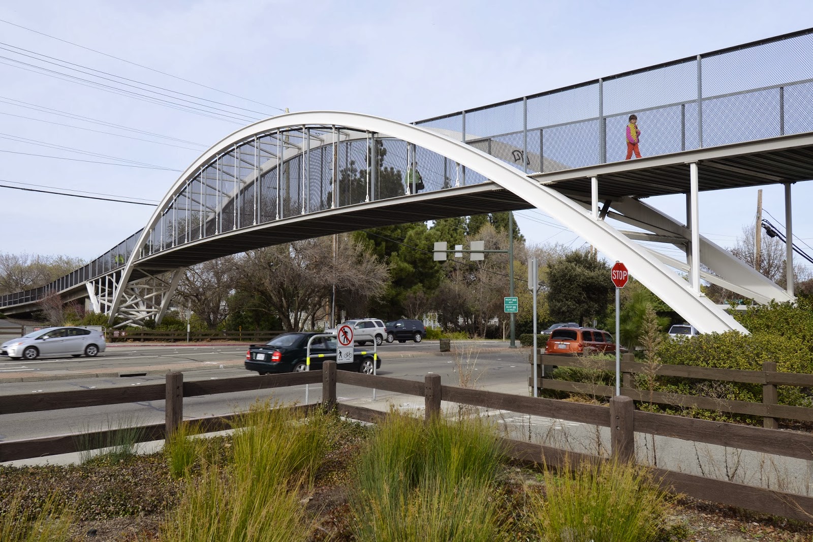
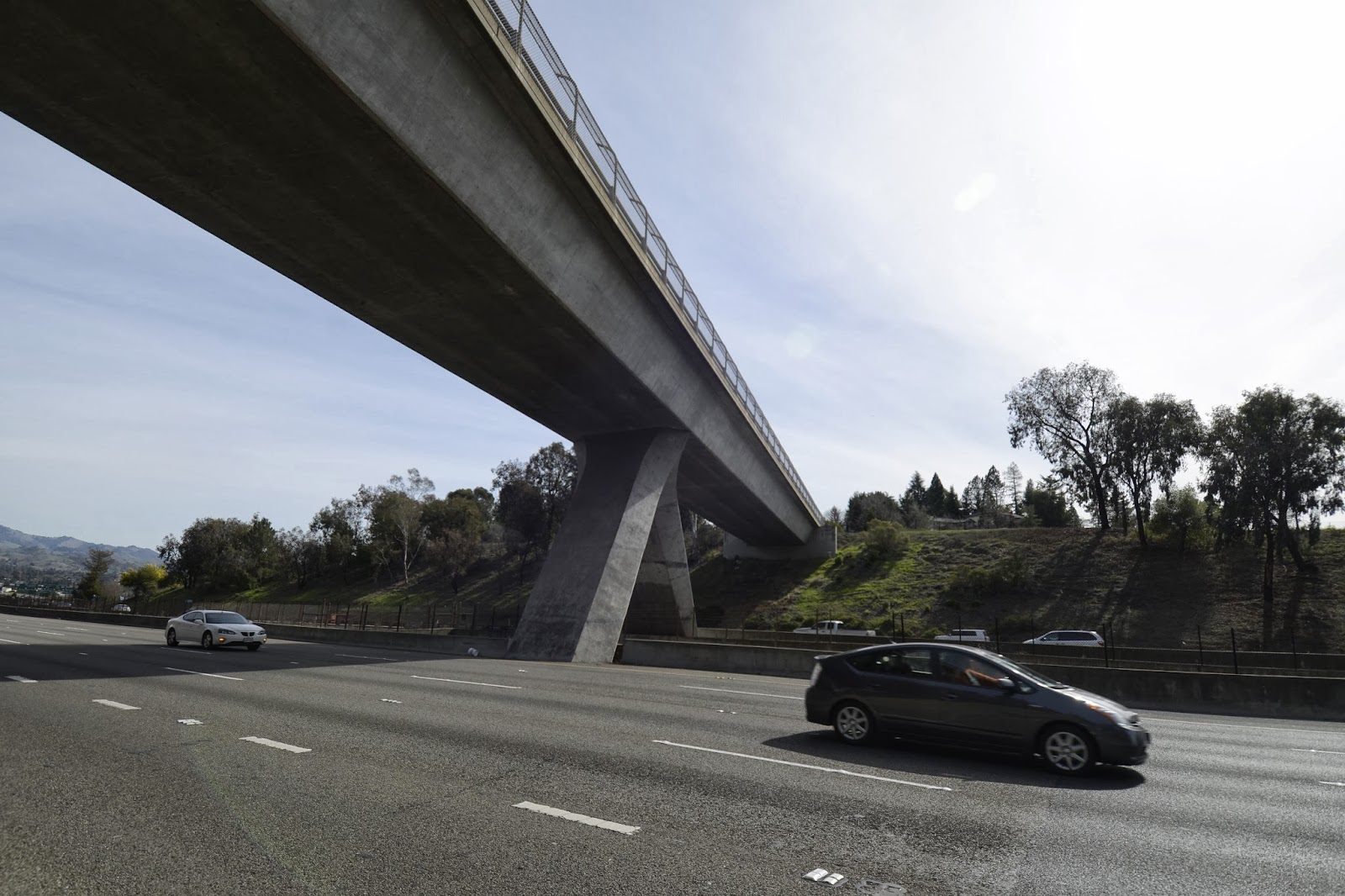
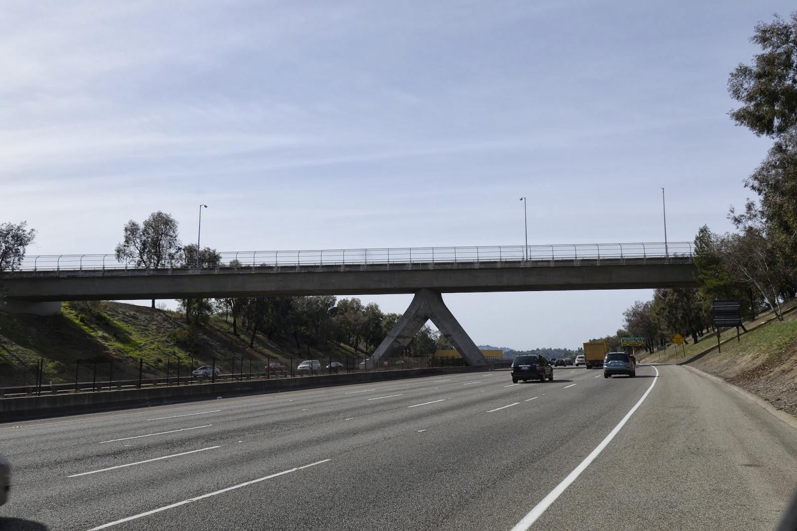
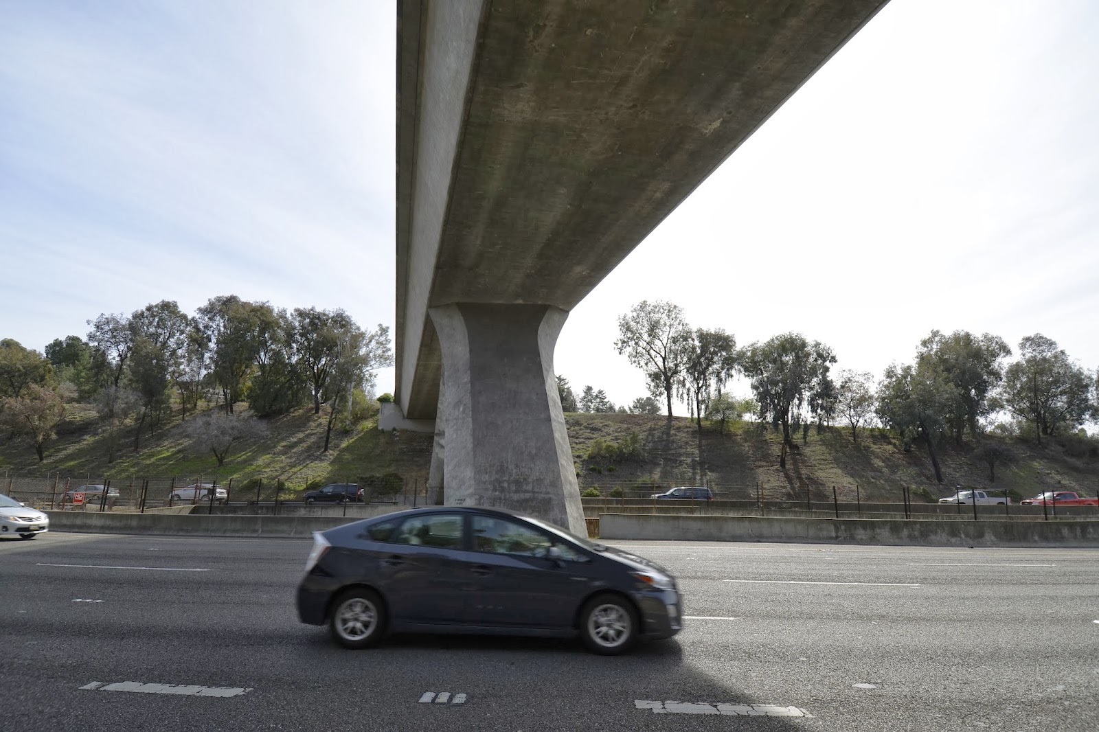
One of the nicest bridges on the Iron Horse Hiking Trail is the Robert I. Schroder Pedestrian Overcrossing in Pleasant Hill. This tied arch bridge was designed by Arup of San Francisco, it cost $6.8 million, and it was completed in October of 2010. It's an 800 ft long steel structure with a concrete substructure and a 10 ft wide deck. The bridge has a steel box girder superstructure supported by outward-inclining steel arches that rise 42 ft above Treat Blvd. 
Each arch rib is composed of three steel pipes bolted to wedge-shaped steel diaphragms. The ends of the steel arch ribs are connected with a steel cross brace and anchored into cylindrical reinforced concrete legs that are part of a single large foundation. The main span is 240 ft long and supported by pairs of crossed cables (40 ft apart) hanging from the wedge-shaped steel diaphragms.
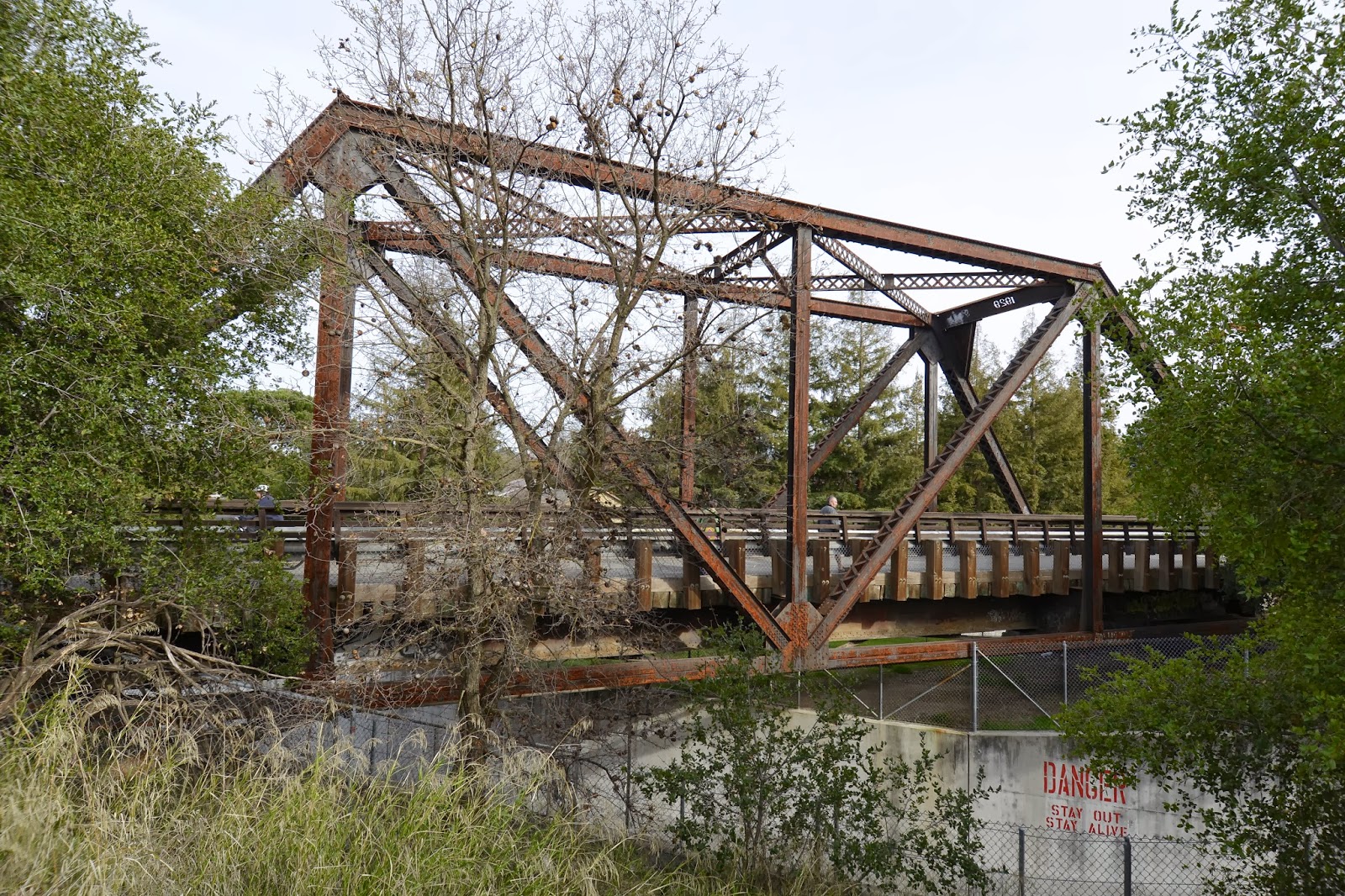
This is an efficiently designed structure. A cylindrical concrete column is placed squarely between the concrete legs of the arch ribs. The steel diaphragms brace the pipe elements of the arch ribs and also carry the weight of the deck. In the past arch ribs were parallel or inclined together into a basket-handle shape but now outward inclining arch ribs seem to be popular.
My friend Richard Hartzell mentioned that the bridge is on a horizontal curve and so each arch rib has a different slope to accommodate the curve, which must have been difficult to analyze and design. More information about this bridge can be found on the Arup website.
Creative Commons License
Contra Costa County, California Bridges: Robert I. Schroder Pedestrian Overcrossing across Treat Blvd by Mark Yashinsky is licensed under a Creative Commons Attribution-NonCommercial-NoDerivatives 4.0 International License.

Monday, February 24, 2014

Contra Costa County, California Bridges: Iron Horse (and Contra Costa Canal) Footbridges

February 2014 (37.9217 Degrees, -122.0606 Degrees) Iron Horse (and Contra Costa Canal) Trails
The Iron Horse Trail extends from Dublin all the way to Martinez (a distance of about 55 miles). The trail was part of the Southern Pacific Railroad right of way from 1891 until it was abandoned in 1977. We've seen several other counties (El Dorado County, Yolo County, etc.) that have turned their abandoned railroad tracks into parks and trails. This part of Contra Costa County is called the 'East Bay' and is an idyllic area to go for a walk or a ride.
I spent some time hiking the Iron Horse Trail and the adjacent Contra Costa Canal Trail (see photo) in Walnut Creek. However, these trails were narrow and without any markings to separate bicyclists from pedestrians. It became nerve wracking as the bicyclists were constantly interrupting my reverie with calls of "On your left!"  There are several old and new footbridges on the trail, which we will be studying over the next few days.
Creative Commons License
Contra Costa County, California Bridges: Iron Horse (and Contra Costa Canal) Footbridges by Mark Yashinsky is licensed under a Creative Commons Attribution-NonCommercial-NoDerivatives 4.0 International License.

Sunday, February 23, 2014

Contra Costa County, California Bridges: 680/24 Interchange in Walnut Creek

February 2014 (37.8963 Degrees, -122.0734 Degrees) 680/24 Interchange
Just east of EL Curtola OC is the 680/24 Interchange with connectors, separators, overcrossings, and undercrossings all climbing over each other. Many of my friends worked on this interchange in the 1990s as part of Caltrans engineer rotation program.
These photos hardly do justice to the many soaring bridges in this interchange (I was too nervous to stop in the middle of the expressway to take a photo). Most of the bridges are cast in place prestressed concrete structures, but there was a temporary steel girder bridge that sat on isolation bearings for several years and then was picked up at the end of the project and placed on its new substructure.
The interchange (and El Curtola OC) can be seen in the Google earth photo shown above (the blue lines are a few of the many earthquake faults in the area. The urban area east of the Interchange is the affluent city of Walnut Creek which we will be exploring over the next few days. 
Creative Commons License
Contra Costa County, California Bridges: 680/24 Interchange in Walnut Creek by Mark Yashinsky is licensed under a Creative Commons Attribution-NonCommercial-NoDerivatives 4.0 International License.

Saturday, February 22, 2014

Contra Costa County, California Bridges: El Curtola Overcrossing over State Route 24

February 2014 (37.89803 Degrees, -122.085002 Degrees) El Curtola OC
The El Curtola Bridge (28 0125) across State Route 24 is supported by an unusual upside-down 'V shaped bent. The bent splits in two to step over the Bay Area Rapid Transit (BART) tracks in the middle of the expressway. The tracks are in a trench that becomes a tunnel just east of the bridge.
I previously wrote about this bridge in April of 2010 and mentioned that the bridge had later been retrofitted with steel column casings. However, when I returned this week there were still no column casings! The bridge was constructed in 1971 and improved in 1996, but the improvements apparently didn't include a column casing (it could have been a concrete casing). It will be interesting to see how this oddly-shaped bent performs during the next big earthquake. This area of Contra Costa County is crossed with many faults, including the Franklin Fault that crosses under the adjacent 24/680 Interchange that we will be studying tomorrow.
The El Curtola OC is a cast-in-place prestressed concrete, box girder bridge with two 194 ft long spans and a single very unusual bent. It seems like they could have built this bridge more traditionally with a bent on either side of the BART tracks, but maybe they wanted the columns sloping away from traffic.
Creative Commons License
Contra Costa County, California Bridges: El Curtola Overcrossing over State Route 24 by Mark Yashinsky is licensed under a Creative Commons Attribution-NonCommercial-NoDerivatives 4.0 International License.

Friday, February 21, 2014

Contra Costa County, California Bridges: Benicia Martinez Bridges across the Carquinez Strait

February 2014 (38.0415 Degrees, -122.12330 Degrees) Benicia Martinez Bridges
Some bridges that we recently viewed from Solano County make another appearance in Contra Costa County. The Benicia Martinez Bridges include a new segmentally constructed prestressed concrete box girder bridge that carries northbound I-680. Just behind it is the Southern Pacific Railroad Bridge composed of camelback Warren trusses, a lift span over the channel, and a deck truss approach. Behind the much lower railroad bridge is a tall deck truss bridge that carries southbound I-680.
Creative Commons License
Contra Costa County, California Bridges: Benicia Martinez Bridges across the Carquinez Strait by Mark Yashinsky is licensed under a Creative Commons Attribution-NonCommercial-NoDerivatives 4.0 International License.

Thursday, February 20, 2014

Contra Costa County, California Bridges: Pacheco Slough Bridges in Martinez

February 2014 (38.03142 Degrees, -122.08008 Degrees) Pacheco Slough Bridges
Another movable railroad bridge in Contra Costa County carries trains across Pacheco Slough in Martinez. It's a long timber trestle bridge with pony truss swing spans at the east end. This bridge was built in 1901 by the Southern Pacific Railroad.
On the north side of the railroad bridge is another swing bridge built in 1946 to carry Waterfront Road. This Pacheco Slough Bridge (28C0006) was improved in 1965 with precast girder approach spans and steel girder swing spans. There is also a utility truss bridge just north of the roadway bridge that carries pipelines to a nearby refinery (see photo below).
Creative Commons License
Contra Costa County, California Bridges: Pacheco Slough Bridges in Martinez by Mark Yashinsky is licensed under a Creative Commons Attribution-NonCommercial-NoDerivatives 4.0 International License.

Wednesday, February 19, 2014

Contra Costa County, California Bridges: Woodward Island RR Bridge across the Old River

February 2014 (37.94127 Degrees, -121.55907 Degrees) Washington Island Railroad Bridge
We are continuing our study of movable bridges in Contra Costa County. Just downstream from yesterday's State Route 4 Bridge is the Woodward Island Railroad Bridge across the Old River. Like the previously studied Indian Slough Railroad Bridge, this bridge carries the BNSF Railroad and Amtrak between Stockton and Martinez.

The Woodward Island RR Bridge has concrete trestle approaches and plate girder/through truss bascule spans. According to the Bridgehunter, this is one of only 8 remaining bridges that use Hugo A.F. Abt's patented design. In this design the counterweight swings under the tall truss while lifting the plate girder span. This allows the approach to remain open under the counterweight. This odd design allows a replacement Abt bridge to be built on the same alignment in the open position facing the other bridge. Terry Koglin describes this solution for movable bridge replacement in his book, "Movable Bridge Engineering." I would imagine that the deck of the replacement bridge must wait until after the old bridge is removed.
Today's bridge was built by the American Bridge Company in 1929. It has a 177 ft long bascule section with a 90 ft long span over the channel with 11 ft of vertical clearance in the closed position.
Creative Commons License
Contra Costa County, California Bridges: Woodward Island RR Bridge across the Old River by Mark Yashinsky is licensed under a Creative Commons Attribution-NonCommercial-NoDerivatives 4.0 International License.

Tuesday, February 18, 2014

Contra Costa County, California Bridges, State Route 4 Bridge across the Old River

February 2014 (37.89072 Degrees, -121.57039 Degrees) Old River Bridge
The California Delta has many movable bridges. This swing bridge carries State Route 4 across the Old River between Contra Costa and San Joaquin Counties. The Old River Bridge (29 0045) was built in 1917 but it was considerably renovated in 1978 and it looks almost new.
A closer inspection shows that the bridge was put together with rivets and laced cross members. In fact, the bridge is in poor shape and has a sufficiency rating for the superstructure of only 22 and is rated structurally deficient.

The Old River Bridge has Howe truss swing spans and Pratt truss approach spans. The bridge is 528 ft long with a 20 ft wide deck. It provides 15.5 ft of vertical clearance below the cross beam and 13 ft vertical clearance above the river in the closed position. The highway makes a sharp 'S' to cross the river at a right angle. Broad levees on each bank protect the surrounding farmland from flooding.
Creative Commons License
Contra Costa County, California Bridges, State Route 4 Bridge across the Old River by Mark Yashinsky is licensed under a Creative Commons Attribution-NonCommercial-NoDerivatives 4.0 International License.

Monday, February 17, 2014

Contra Costa County, California Bridges: Indian Slough Bridges

February 2014 (37.93889 Degrees, -121.61000 Degrees) Indian Slough Bridges
Around the Antioch Bridge is the California Delta, a maze of sloughs and swampy islands. California's Delta has similar problems to the ones that plague the Mississippi Delta. It's below sea level and protected by gates and levees. The state government wants to divert some of the water into tunnels for farmers and wildlife habitats, but this plan is fiercely opposed by the people who live in the Delta.

We'll spend the next few days studying a few of the bridges that cross the Delta in Contra Costa County.
Indian Slough is crossed by several bridges at Orwood Road a little north of the waterfront community of Discovery Bay.  A squat concrete trestle bridge carries Amtrak and BNSF trains across the slough (top photo). Three large diameter utility bridges cross the slough to bring fresh water to communities in the Bay (see photo above). The utility bridge to the north has a seismic retrofit with lead rubber bearings supporting a steel eccentrically braced frame that will act as a fuse for transverse displacement (see photo below).
Just south of the utility bridges, the Orwood Road Bridge (28C0024) crosses Indian Slough. It's a twelve span timber trestle bridge with a reinforced concrete deck (see photo below). This road bridge is 230 ft long, 22 ft wide, and it was built in 1947.
Creative Commons License
Contra Costa County, California Bridges: Indian Slough Bridges by Mark Yashinsky is licensed under a Creative Commons Attribution-NonCommercial-NoDerivatives 4.0 International License.

Sunday, February 16, 2014

Contra Costa County, California Bridges: State Route 160 (Antioch) Bridge across the San Joaquin River (2)

February 2014 (38.02400, -121.75162) Antioch Bridge
The Antioch Bridge (28 0009) is a narrow, two lane toll bridge that carries State Route 160 across the San Joaquin River. It was built in 1978 with continuous steel girders. It's  a 40 span, 9440 ft long steel girder bridge with a 460 ft span across the shipping channel. In the photo above we can see how steeply the bridge rises to provide 140 ft of vertical clearance over the river. The bridge includes gates to stop traffic when the wind starts blowing. The toll plaza is on the opposite (west) side but one can avoid the toll altogether by driving across the river a little downstream on State Route 4.
This Caltrans bridge was designed by my boss Chuck Yakabe in the 1970s and the retrofit was completed last year by Kim Yong-Pil. It includes friction pendulum bearings just slightly higher than the existing bearings that can move 0.6 meters for the design earthquake. More information on the retrofit is available on the Internet.
Creative Commons License
Contra Costa County, California Bridges: State Route 160 (Antioch) Bridge across the San Joaquin River (2) by Mark Yashinsky is licensed under a Creative Commons Attribution-NonCommercial-NoDerivatives 4.0 International License.