Sunday, September 30, 2012

Niigata Japan's Bridges: Japan Rail Bridges across the U River (1)

August 2007 (37.3619 Degrees, 138.5493 Degrees) Japan Railway Bridges
Continuing up the U River from the Osu Bridge are a pair of railway bridges. I wonder if one bridge carries passenger trains and the other carries freight trains? They are both through girder bridges on seat-type abutments and pier walls.  They are much beefier than the road bridges we had previously studied.
When we arrived on August 6th, a rail crew was re-attaching the rails and there was new ballast on the approaches.  However, they went off to lunch before we could ask them if they were repairing earthquake damage.  The rails were rusty, suggesting they hadn’t been used in awhile, but its possible that the railway was closed due to damage south at Omigawa Station or north at Kashiwazaki Station.  The bridges were built in 1997.

Creative Commons License
Niigata Japan's Bridges: Japan Rail Bridges across the U River (1) by Mark Yashinsky is licensed under a Creative Commons Attribution-NonCommercial-ShareAlike 3.0 United States License.

Saturday, September 29, 2012

Niigata Japan's Bridges: Osu Bridge across the U River (3)

August 2007 (37.3635 Degrees, 138.5478 Degrees) Osu Bashi
Although the tall, south abutment had all the embankment damage I didn't see any signs that the waterline was damaged. However, the short, north abutment was covered in water. There's a waterline on each side of the bridge and so they might have repaired the one on the east side of the bridge earlier.

Not only was the north abutment wet, but it looked like the box girder had banged pretty hard into the backwall. Also, note just a single bearing is supporting the superstructure.

Back on the northwest side of the bridge is another plaque giving the pertinent facts about the design and construction of the Osu Bridge. It says 1978 and 1983 which must be the dates when it was designed and constructed.
Creative Commons License
Niigata Japan's Bridges: Osu Bridge across the U River (3) by Mark Yashinsky is licensed under a Creative Commons Attribution-NonCommercial-ShareAlike 3.0 United States License.

Friday, September 28, 2012

Niigata Japan's Bridges: Osu Bridge across the U River (2)

August 2007 (37.3635 Degrees, 138.5478 Degrees) Osu Bashi
The south end of the bridge (with the tall abutment) had a lot more damage than the north end during the 2007 earthquake due to the embankment settling almost two meters and breaking a water line.
Like the other bridges across the U River, the Osu Bridge has pedestals with name plaques that also serve to support the barrier rail. I wonder why they have a fence on the west side of the bridge but not the east side?

Tomorrow we'll take a look under the bridge.
Creative Commons License
Niigata Japan's Bridges: Osu Bridge across the U River (2) by Mark Yashinsky is licensed under a Creative Commons Attribution-NonCommercial-ShareAlike 3.0 United States License.

Thursday, September 27, 2012

Niigata Japan's Bridges: Osu Bridge across the U River (1)

August 2007 (37.3635 Degrees, 138.5478 Degrees) Osu Bashi
The fourth bridge across the U River is a narrow (6 m wide) two-span concrete box girder bridge on a single-column bent and one tall and one short abutment that had more damage than the previous two bridges.  Although the south levee moved very little, the embankment between the levee and the bridge settled a meter and there was damage to the abutment including a leaking waterline.
Creative Commons License
Niigata Japan's Bridges: Osu Bridge across the U River (1) by Mark Yashinsky is licensed under a Creative Commons Attribution-NonCommercial-ShareAlike 3.0 United States License.

Wednesday, September 26, 2012

Niigata Japan's Bridges: Ukawa Bridge across the Ugawa (2)

August 2007 (37.3641 Degrees, 138.5462 Degrees) Ukawa Bridge
Looking back downstream at the Ukawa Bridge.

It seems like most Japanese neighborhoods still have overhead distribution lines. The houses in Kashiwazaki are a mix of more modern and more traditional Japanese homes. After the earthquake, I noticed that many of the homes used propane tanks instead of natural gas pipelines. It must have varied by neighborhood though because our hotel didn't have hot water after the earthquake.

The river levees are covered in traditional Japanese slope paving, which remained intact at this location after the earthquake.
The bridge railing combines a tubular handrail with a modern undulating fence. Note the red floodgate controlling the flow of water from a tiny canal into the river.
Creative Commons License
Niigata Japan's Bridges: Ukawa Bridge across the Ugawa (2) by Mark Yashinsky is licensed under a Creative Commons Attribution-NonCommercial-ShareAlike 3.0 United States License.

Tuesday, September 25, 2012

Niigata Japan's Bridges: Ukawa Bridge across the Ugawa (1)

August 2007 (37.3641 Degrees, 138.5462 Degrees) Ukawa Bridge
Continuing upstream another 300 meters, we came to the third bridge across the Ugawa. The Ukawa bridge is two simple ‘I’ girder spans supported by a pier wall and seat-type abutments.  All of these bridges are about 60 meters long. The only damage  from the Kashiwazaki earthquake was some settlement of the sidewalk on the south end of the bridge.
We've been looking at the decorations at the ends of the U River crossings. The Ukawa Bridge just has pedestals with name plates and lamps, mounted on the wingwalls for some reason.

Creative Commons License
Niigata Japan's Bridges: Ukawa Bridge across the Ugawa (1) by Mark Yashinsky is licensed under a Creative Commons Attribution-NonCommercial-ShareAlike 3.0 United States License.

Monday, September 24, 2012

Niigata, Japan's Bridges: Yasaka Bridge across the U River (2)

August 2007 (N37.3658° E138.5438°) Yasaka Bridge
Another view of the Yasaka Bridge over the U River. I've mentioned the Japanese penchant for objets d'art at the ends of their bridges. I'm not sure what the objects on the Yasaka Bridge are meant to signify. Maybe some kind of foliage or a trained seal balancing a ball on it's nose?
Creative Commons License
Niigata, Japan's Bridges: Yasaka Bridge across the U River (2) by Mark Yashinsky is licensed under a Creative Commons Attribution-NonCommercial-ShareAlike 3.0 United States License.

Sunday, September 23, 2012

Niigata, Japan's Bridges: Yasaka Bridge across the U River (1)

August 2007 (N37.3658° E138.5438°) Yasaka Bridge
Walking along the levee from the Rinko Yasaka to the Yasaka Bridge. 'Rinko' means superior or first and so this is the second Yasaka Bridge. Like most of the bridges over the Ugawa, this is a two span, simply-supported river crossing, but with steel girders, and supported on a pier wall and seat-type abutments.  It is about 200 meters upstream from the more heavily damaged Rinko Yasaka Bridge, but the soil was much firmer at this site, there was less than 100 cm of settlement at the approaches, and no damage to the abutments or wingwalls.
Creative Commons License
Niigata, Japan's Bridges: Yasaka Bridge across the U River (1) by Mark Yashinsky is licensed under a Creative Commons Attribution-NonCommercial-ShareAlike 3.0 United States License.

Saturday, September 22, 2012

Niigata, Japan's Bridges: Rinko Yasaka Bridge across the U River (4)

August 2007 (37.3675 Degrees, 138.5433 Degrees) Rinko Yasaka Bridge
A combination of lateral spreading of the embankment and movement of the abutment backwall caused quite a bit of bridge damage without closing the bridge for very long.
As long as the abutment has big seats, the superstructure is well put together, and everything is sitting on deep piles the bridge can handle a lot banging without being closed for longer than it takes to put some asphalt on the approaches.

Creative Commons License
Niigata, Japan's Bridges: Rinko Yasaka Bridge across the U River (4) by Mark Yashinsky is licensed under a Creative Commons Attribution-NonCommercial-ShareAlike 3.0 United States License.

Friday, September 21, 2012

Niigata, Japan's Bridges: Rinko Yasaka Bridge across the U River (3)

August 2007 (37.3675 Degrees, 138.5433 Degrees) Rinko Yasaka Bridge
Looking downstream at the Rinko Yasaka Bridge, which is a two span precast I girder bridge across the U River  in Kashiwazaki. This bridge sustained quite a bit of damage without losing much functionality (once the embankments were repaired). For a precast bridge, it has some nice features. Like the previously studied Aumegawa Bridge, it's partially covered in ivy. It provides a nice view of the Sea of Japan. It includes a plinth with a decorative tablet giving the bridge's name.

We'll study the bridge damage from the 2007 earthquake in more detail tomorrow.
Creative Commons License
Niigata, Japan's Bridges: Rinko Yasaka Bridge across the U River (3) by Mark Yashinsky is licensed under a Creative Commons Attribution-NonCommercial-ShareAlike 3.0 United States License.

Thursday, September 20, 2012

Niigata, Japan's Bridges: Rinko Yasaka Bridge across the U River (2)

August 2007 (37.3675 Degrees, 138.5433 Degrees) Rinko Yasaka Bridge
Another view of the Rinko Yasaka Bridge. It looks like they were doing some work at the pier when we visited after the 2007 earthquake. They were probably repairing or replacing the bearings.
Lateral spreading of the river embankments and shaking of the bridge caused quite a bit of minor damage which was exacerbated by the sharp abutment angles of the skewed bridge. We'll take another look at this bridge tomorrow.
Creative Commons License
Niigata, Japan's Bridges: Rinko Yasaka Bridge across the U River (2) by Mark Yashinsky is licensed under a Creative Commons Attribution-NonCommercial-ShareAlike 3.0 United States License.

Wednesday, September 19, 2012

Niigata, Japan's Bridges: Rinko Yasaka Bridge across the U River (1)

August 2007 (37.3675 Degrees, 138.5433 Degrees) Rinko Yasaka Bridge
We left the mountains south of town to look at the bridges across the U River. Unlike the Sabaishi (which had lateral spreading for about 5 km upstream), the banks of the Ugawa (a river south of the Sabaishi in Kashiwazaki) only had laterally spreading for about one km from the mouth of the river. This may be due to the more meandering path of the Sabaishi which resulted in more sediment being dropped along the banks. Also, the Sabaishi travels along a large sand dune with poorly compacted soil.

Another difference between these two rivers is that the Ugawa has eight meter high levees built up along the banks and much greater flood protection (pumps and gates).  Perhaps it is this tendency of the Ugawa to flood that periodically cleans its banks of loose sediment.  At 
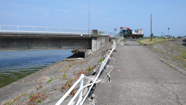
any rate, the tall dikes meant that when the banks spread, they carried more material, and caused damage to the slope paving and flood control facilities.

The first bridge upstream from the mouth of the U River is a two span concrete I girder bridge on seat abutments and a single column bent with a hammerhead cap. This location had the most lateral spreading on the Ugawa.  The entire levee was dragged toward the river and the abutment was damaged and separated from the wingwall. We'll take a closer look at this bridge tomorrow.
Creative Commons License
Niigata, Japan's Bridges: Rinko Yasaka Bridge across the U River (1) by Mark Yashinsky is licensed under a Creative Commons Attribution-NonCommercial-ShareAlike 3.0 United States License.

Tuesday, September 18, 2012

Niigata, Japan's Bridges: Aumegawa Bridges on the Horukiru Expressway (3)

August 2007 (37.343 Degrees, 138.482 Degrees) Aumegawa Bridges
Another photo of the Aumegawa (a better spelling may be Oumigawa) Bridge in Niigata. It looks like the bridge owner has encouraged the growth of ivy on the piers. There's already so much greenery around this bridge that no more is needed. Also after earthquakes, one might assume they would remove the ivy to check for shear cracks on the piers. However, this was apparently not the case after the 2007 Kashiwazaki Earthquake. Although the bearings were damaged, the ivy remained in place.
Creative Commons License
Niigata, Japan's Bridges: Aumegawa Bridges on the Horukiru Expressway (3) by Mark Yashinsky is licensed under a Creative Commons Attribution-NonCommercial-ShareAlike 3.0 United States License.

Monday, September 17, 2012

Niigata, Japan's Bridges: Aumegawa Bridges on the Horukiru Expressway (2)

August 2007 (37.343 Degrees, 138.482 Degrees) Aumegawa Bridges
Another view of the Aumegawa Bridge south of Kashiwazaki. Looking at these shiny silver superstructures it would be easy to assume they are steel box girder bridges, except my notes say otherwise. In California, painting a concrete bridge would be considered a wasteful indulgence since there is barely enough money to paint the steel bridges.

I looked at Google Earth to see if anyone had commented on this bridge, but this area wasn't even photographed by Google and it has few comments. Perhaps this is one of the less frequented areas of Japan.
Creative Commons License
Niigata, Japan's Bridges: Aumegawa Bridges on the Horukiru Expressway (2) by Mark Yashinsky is licensed under a Creative Commons Attribution-NonCommercial-ShareAlike 3.0 United States License.

Sunday, September 16, 2012

Niigata, Japan's Bridges: Agewa River Bridges

August 2007 (37.326 Degrees, 138.452 Degrees) Agewa River Bridges
Looking down at the various bridges crossing the narrow mouth of the Agewa River. The railroad bridge in the foreground carries trains between tunnels. The bridge along the Sea of Japan was closed after the 2007 earthquake due to all the landslides which isolated the fishing communities along the coast.
Creative Commons License
Niigata, Japan's Bridges: Agewa River Bridges by Mark Yashinsky is licensed under a Creative Commons Attribution-NonCommercial-ShareAlike 3.0 United States License.

Saturday, September 15, 2012

Niigata, Japan's Bridges: Agewa Ohashi Bridge (上輪大橋) on Route 8 (3)

August 2007 (37.325 Degrees, 138.454 Degrees) Agewa Ohashi
One last photo of the Agewa Bridge. The dense vegetation reflects the heavy rainfall and temperate climate along the west coast of Japan.

The spandrel bridge columns have slender diagonal members at the top sloping towards the center of the arch ribs to keep the whole thing stable. They did a remarkable job of preventing bridge damage during the 2007 earthquake.
Creative Commons License
Niigata, Japan's Bridges: Agewa Ohashi Bridge (上輪大橋) on Route 8 (3) by Mark Yashinsky is licensed under a Creative Commons Attribution-NonCommercial-ShareAlike 3.0 United States License.

Friday, September 14, 2012

Niigata, Japan's Bridges: Agewa Ohashi Bridge (上輪大橋) on Route 8 (2)

August 2007 (37.325 Degrees, 138.454 Degrees) Agewa Ohashi
A photo of the Agewa Bridge in front of the Sea of Japan. The bridge has long steel girder approaches because the arch is supported on sloping terrain.
Creative Commons License
Niigata, Japan's Bridges: Agewa Ohashi Bridge (上輪大橋) on Route 8 (2) by Mark Yashinsky is licensed under a Creative Commons Attribution-NonCommercial-ShareAlike 3.0 United States License.

Thursday, September 13, 2012

Niigata, Japan's Bridges: Agewa Ohashi Bridge (上輪大橋) on Route 8 (1)

August 2007 (37.325 Degrees, 138.454 Degrees) Agewa Ohashi
Just east of the Yonahime Bridge is a long bridge over the Agewa River. The Agewa Bridge is a steel deck arch firmly anchored into the hillside, which (unlike the Yonahime Bridge) suffered no damage during the 1997 Kashiwazaki Earthquake.
Creative Commons License
Niigata, Japan's Bridges: Agewa Ohashi Bridge (上輪大橋) on Route 8 (1) by Mark Yashinsky is licensed under a Creative Commons Attribution-NonCommercial-ShareAlike 3.0 United States License.