Thursday, October 31, 2013

Yuba County, California Bridges: Union Pacific Bridge across the Feather River

October 2013 (39.16364 Degrees, -121.61284) UP Trestle Bridge
Continuing upstream along the Feather River Bridge is an old Union Pacific Trestle Bridge with concrete piers supporting truss spans over the river. A really big caisson supports the river pier to protect it from debris coming downstream.
I wonder if the bridge was raised at some point and the rings around the piers is where the top used to be? The Union Pacific comes north out of Marysville on a big curve, crossing the river in a westerly direction and then goes north through Sutter County (see Google earth photo below).
On the east side of the river are precast box girder spans supported on steel H piles with reinforced concrete bent caps.
Creative Commons License
Yuba County, California Bridges: Union Pacific Bridge across the Feather River by Mark Yashinsky is licensed under a Creative Commons Attribution-NonCommercial-NoDerivs 3.0 Unported License.

Wednesday, October 30, 2013

Yuba County, California Bridges: Colusa Highway (Route 20) Bridge across the Feather River

October 2013 (39.14333 Degrees, -121.60667 Degrees) Colusa Highway Bridge
Continuing northward we arrived at the  24-span Feather River Bridge and Overhead (18 0009) a continuous steel girder bridge that carries the Colusa Highway (Route 20) over the river. It was built in 1947 and widened in 1994. 
The Feather River BOH has a length of 2674 ft including two 160 ft long haunched girder spans across the river. It's 68 ft wide and carries four traffic lanes and sidewalks. 

The long approach structure is supported on oval columns projecting up from pierwalls. My favorite feature is the delicate pale green railings with twisted vertical elements and wave-like horizontal elements.
Creative Commons License
Yuba County, California Bridges: Colusa Highway (Route 20) Bridge across the Feather River by Mark Yashinsky is licensed under a Creative Commons Attribution-NonCommercial-NoDerivs 3.0 Unported License.

Tuesday, October 29, 2013

Yuba County, California Bridges: 5th Street Underpass over the BNSF Railroad

October 2013 (39.13944 Degrees, -121.59944 Degrees) 5th Street UP
A little east of yesterday's bridges is the 5th Street Underpass (16C0024), a railroad bridge that was built in 1907 to carry the BNSF Railroad over 5th Street in Marysville. It's an highly ornamented four span reinforced concrete slab bridge on multicolumn bents. Among its interesting features are haunched girders, diamond-shaped holes in the red brick barrier, corbels supporting an exterior facade painted blue, etc.
Creative Commons License
Yuba County, California Bridges: 5th Street Underpass over the BNSF Railroad by Mark Yashinsky is licensed under a Creative Commons Attribution-NonCommercial-NoDerivs 3.0 Unported License.

Monday, October 28, 2013

Yuba County, California Bridges: 5th Street Bridge across the Feather River

October 2013 (39.13864 Degrees, -121.60698 Degrees) 5th Street Bridge
The Feather River (or 5th Street) Bridge (12C0012) is about to be replaced with a bigger bridge further to the north of its historic neighbor. The existing bridge is an 1,865 ft long precast simple span I girder bridge that was built in 1958 and widened with a 10 ft pedestrian and bicycle path attached to the north exterior girder with steel braces (see photo above). This bridge will be replaced a little upstream with a four lane bridge with bigger sidewalks and shoulders. Meanwhile, the historic Twin Cities Bridge will remain and (hopefully) be improved with a deck to support pedestrians and bicyclists.

On the west side of the river (in Yuba City) 5th Street, which is now Bridge Street crosses over 2nd Street with a similarly designed two span bridge that was also built in 1958 (see photo below). More information on all of these bridges can be found in the Environmental Impact Report for the replacement bridges.


Creative Commons License
Yuba County, California Bridges: 5th Street Bridge across the Feather River by Mark Yashinsky is licensed under a Creative Commons Attribution-NonCommercial-NoDerivs 3.0 Unported License.

Sunday, October 27, 2013

Yuba County, California Bridges: Twin Cities Memorial Bridge across the Feather River

May 2010 (39.13877 Degrees, -121.60622 Degrees) Twin Cities Memorial Bridge
Warren, Pratt, and Howe trusses look somewhat similar, at least from a distance. However, the Warren truss is made up of isosceles triangles, the Pratt truss has diagonal members slanting down toward the middle of the span (to carry tension), and the Howe truss has diagonal members slanting down towards the ends (to carry compression).
The Twin Cities Memorial Bridge is composed of pin-connected Pratt truss spans on concrete dog-bone piers over the Feather River and with a concrete trestle east of the river. The bridge was built in 1906 by the Northern Electric Railroad (NERR) Company to carry people (and freight?) between Sacramento and Chico. The production of cheap hydroelectric power allowed electric interurban rail lines to briefly flourish before the advent of the automobile. This railroad bridge carried people between Yuba City and Marysville, spurring the development of both cities. The NERR alignment veers west of the BNSF RR line (north of yesterday's bridge) and across the Feather River.
The Twin Cities Memorial Bridge was selected for inclusion in the National Register of Historic Places. Besides its historical importance to the region are its distinguishing features including cloverleafs and the letters 'NE' (for Northern Electric) stamped onto the portal frames.
Creative Commons License
Yuba County, California Bridges: Twin City Memorial Bridge across the Feather River by Mark Yashinsky is licensed under a Creative Commons Attribution-NonCommercial-NoDerivs 3.0 Unported License.

Saturday, October 26, 2013

Yuba County, California Bridges: Twin Cities Memorial Bridges across the Feather River

October 2013 (39.13867 Degrees, -121.60637 Degrees) Feather River Bridges
Continuing west is a pair of bridges across the Feather River, which separates the cities of Marysville and Yuba City. The bridge on the right is called the Twin Cities (or Northern Electric) Railroad Bridge (except there is no longer a railroad and the tracks are gone). The bridge on the left is the Feather River Bridge, which still carries 5th Street across the river.

We'll take a closer look at both bridges tomorrow.
Creative Commons License
Yuba County, California Bridges: Twin Cities Memorial Bridges across the Feather River by Mark Yashinsky is licensed under a Creative Commons Attribution-NonCommercial-NoDerivs 3.0 Unported License.

Friday, October 25, 2013

Yuba County, California Bridges: Burlington Northern and Santa Fe Railroad Bridge across the Yuba River

October 2013 (39.13408 Degrees, -121.59287 Degrees) BNSF Railway Viaduct
The next bridge across the Yuba River is the Burlington Northern and Santa Fe Railroad Bridge, which is made up of Warren truss spans. This five span bridge is 792 ft long with 153 ft long river spans composed of six panels with sloping end panels. An additional 102 ft long truss span goes over Biz Johnson Drive and so it's also called the Biz Johnson Drive Underpass (16C0094). Both bridges were built in 1927.
Creative Commons License
Yuba County, California Bridges: Burlington Northern and Santa Fe Railroad Bridge across the Yuba River by Mark Yashinsky is licensed under a Creative Commons Attribution-NonCommercial-NoDerivs 3.0 Unported License.

Thursday, October 24, 2013

Yuba County, California Bridges: State Route 70 Bridge across the Yuba River

October 2013 (39.1343 Degrees, -121.5895 Degrees) State Route 70 Bridge
The next bridge across the Yuba River is a 27 span continuous concrete box girder bridge on pier walls built in 1960. The State Route 70 Bridge (16 0034) is on wide, thin pier walls. Its 2400 ft long, with 90 ft long river spans, and carries four traffic lanes.
 The bridge appears to be in fairly good shape (SR of 75.4) and carries about 36,000 vehicles a day. Very high gauges on the sides of piers (as well as water stains) suggest the river can get quite high during flood stage.
On the north side of the river is a ramp for carrying pedestrians onto the sidewalk and over the river. The area around the river is full of transients, habitats for humanity, half-way houses, and it appears to support an impoverished population.
Creative Commons License
Yuba County, California Bridges: State Route 70 Bridge across the Yuba River by Mark Yashinsky is licensed under a Creative Commons Attribution-NonCommercial-NoDerivs 3.0 Unported License.

Wednesday, October 23, 2013

Yuba County, California Bridges: Union Pacific RR Viaduct across the Yuba River

October 2013 (39.13602 Degrees, -121.5832 Degrees) UP RR Viaduct
The next bridge across the Yuba River is a long viaduct carrying the Union Pacific Railroad. It's made up of pier walls, two column bents, and other substructure types supporting deep girders over the river and shallow girders over land.
The UP Bridge seems to be built out of whatever they had in the yard. The bridge is in a wide river basin and so they must have needed a really long bridge to carry the train over the river when it rises.

The railroad bridge continues into the city on ugly pier walls and precast slabs as the 2nd Street Underpass (16C0096), the 3rd Street Underpass (16C0098), and the 4th Street Underpass (16C0099).
Creative Commons License
Yuba County, California Bridges: Union Pacific RR Viaduct across the Yuba River by Mark Yashinsky is licensed under a Creative Commons Attribution-NonCommercial-NoDerivs 3.0 Unported License.

Tuesday, October 22, 2013

Yuba County, California Bridges: Simpson Lane Bridge across the Yuba River

October 2013 (39.1419 Degrees, -121.5758 Degrees) Simpson Lane Bridge
North of the confluence of the Feather River and the Yuba River is the city of Marysville, which was a stopping place between Sacramento and San Francisco during the Gold Rush. Hydraulic gold mining raised the river beds so high that the city flooded every winter. A levee system eventually protected the city from floods while restricting further city growth (see Google Earth photo below).Yuba City sits on the west side of the Feather River in  Sutter County.
The Simpson Lane Bridge (16C0001) is the easternmost bridge across the Yuba River in Marysville. It is a five simple span 'T" girder bridge (on a 30 degree skew) that was built in 1957. It looks like the bridge was widened with exterior precast girders, probably to give it legal shoulder widths in 1987.

The superstructure is supported on tall, thin pier walls on oblong foundations cast into what looks like steel soldier piles. Two piers sit in the river, two piers sit on the banks, and the abutments are at the top of the levees, well away from potential flooding.
The bridge is composed of 83 ft long spans for a total length of 418 ft. It has a sufficiency rating of 89, which is pretty good but it has a poor deck rating and it also needs bank protection.
Creative Commons License
Yuba County, California Bridges: Simpson Lane Bridge across the Yuba River by Mark Yashinsky is licensed under a Creative Commons Attribution-NonCommercial-NoDerivs 3.0 Unported License.

Monday, October 21, 2013

Yuba County, California Bridges: Blackford Road Bridge across Camp Far West Dam Spillway

October 2013 (39.0525 Degrees, -121.3194 Degrees) Blackford Road Bridge
The Bear River is one of many tributaries of the Feather River. As can be seen on the map below the Bear River has reservoirs at locations where it was dammed as it flows from the Sierra Mountains into the Feather River.
The Camp Far West Dam was built in 1963 to hold back the water from the Bear River and Rock Creek. It was named for the last immigration camp on the western trail for 49ers coming into the Sacramento Valley. Wheatland is west of the dam and Beale Air Force Base is north of the dam.

The Blackford Road Bridge (16C0081) was built over the spillway for the dam. As homeland security became  more of a concern they began prohibiting people from walking across the bridge (see photo below).
The National Bridge Inventory states that this bridge was built in 1916 and moved to its present site after the dam was completed (in 1966). It's a Pennsylvania Petit Truss Bridge, which was popular for its ability to span over 300 ft. These bridges typically have sloping portal frames leading to speculation that it may have originally been part of a multispan bridge with trusses sitting end to end on the piers.
Creative Commons License
Yuba County, California Bridges: Blackford Road Bridge across Camp Far West Dam Spillway by Mark Yashinsky is licensed under a Creative Commons Attribution-NonCommercial-NoDerivs 3.0 Unported License.

Sunday, October 20, 2013

Yuba County, California Bridges: State Route 65 across the Bear River

October 2013 (38.9999 Degrees, -121.4061 Degrees) State Route 65 Bridge
Highways and railways often share the same right-of-way, and so the State Route 65 Bridge (19 0013) and the Union Pacific Bridge sit side by side across the Bear River. Actually, the SR 65 Bridge is on the south side of the border (which is the Bear River) as shown by the ''19' in its bridge number (for Placer County).
The Bear River Bridge is a 15-span, continuous reinforced concrete T beam viaduct with a 62 ft maximum span length and a 660 ft total length. It's 44.5 ft wide with two traffic lanes and wide sidewalks and shoulders and it was built in 1965 and improved in 1998. It carries about 14000 vehicles a day and has a sufficiency rating of 82%.
This bridge is supported on thin pier walls, which may be a problem if there is much longitudinal earthquake displacement. Secondary moments due to eccentrically applied dead load can push pier walls over, especially if there is a significant gap at the expansion joints.
Creative Commons License
Yuba County, California Bridges: State Route 65 across the Bear River by Mark Yashinsky is licensed under a Creative Commons Attribution-NonCommercial-NoDerivs 3.0 Unported License.

Saturday, October 19, 2013

Yuba County, California Bridges: Union Pacific Railroad Bridge across the Bear River

October 2013 (39.0000 Degrees, -121.4063 Degrees) UP Railroad Bridge
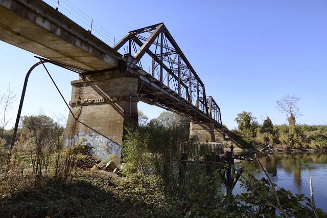
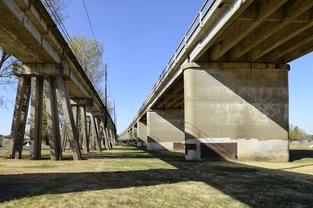
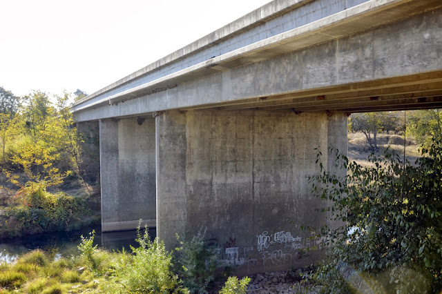
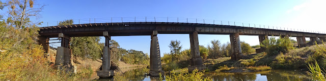
Today's bridge carries the Union Pacific Railway across the Bear River near Wheatland, California. The bridge is composed of steel trestle piers on concrete pier walls on the north (left) side of the river and concrete filled steel casings on the south side of the river.
The superstructure is steel I girders but at the south end of the bridge, the steel girders are replaced by precast concrete girders and the concrete-filled steel casings are replaced with steel trestle piers (see photo above).
Although aesthetics was probably the last thing on the engineer's mind while designing this bridge, it has a peculiar beauty. I particularly like the shape of the concrete river pier.
We are continuing an exploration of bridges in California counties that we began about a year ago. So far we've studied bridges in Placer, Nevada, El Dorado, Amador, Calaveras, Sacramento, Yolo, and now Yuba County (see map below). Since I seem to be dividing my time between bridges in California and Japan, so we'll see whether we finish Japan's 47 prefectures or California's 58 counties first.
Creative Commons License
Yuba County, California Bridges: Union Pacific Railroad Bridge across the Bear River by Mark Yashinsky is licensed under a Creative Commons Attribution-NonCommercial-NoDerivs 3.0 Unported License.